- Florence to begin interviewing police chief finalists in January
- A West Texas county wants to better prepare for floods. Paying for it will be tricky.
- They couldn’t save their daughters’ lives in the July 4 floods. Now they’re dealing with the grief and the guilt.
- Austin could see heavy rains, possible flooding over the next few days
- Families of campers, counselors who died in Texas Hill County floods sue Camp Mystic
Flooding conditions possible from NC rivers after Debby
Rivers southeast of the Triangle are creating flooding conditions Friday as the remnants of post-tropical cyclone Debby move farther away from North Carolina.
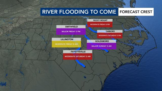
Flood warnings have been extended into Monday for many central N.C. counties as rivers rise, including areas along the Neuse River at Smithfield, the Neuse River at Clayton and the Neuse River at Goldsboro, affecting Wayne County.
The Lumber River in Lumberton was at major flood stage (19 to 20 feet) Friday and may not drop into moderate flood stage (16 feet) until Sunday night. According to the National Weather Service, dozens of homes could be impacted, and roads could be closed in the Pines and Cox Ponds areas. Carthage Road may be completely covered with water.
The Neuse River in Clayton has created minor flooding on the greenway, but river levels are expected to decrease. The Neuse River at Smithfield is expected to reach major flood stage on Friday.
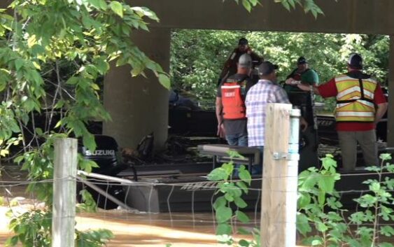
NC DOT crews were at the Neuse River in Smithfield, clearing log jams and floating islands of trash.
“Every bottle of can thrown out along the roadways can eventually end up in the creeks, streams, rivers and eventually the ocean,” said one worker.
Crews pushed through the brown, debris laden river waters, trying to keep up with the onslaught of trash, sending much of it downstream.
Debris which collects around bridge supports is a hazard to boaters and can lead to structural damage to bridges.
Several other rivers have reached major or moderate flood stage. Even moderate flood stage can cause flooding issues and damage well after a tropical system moves away, according to WRAL meteorologist Elizabeth Gardner.
Updated at 11 a.m. on Aug. 9: The latest local river forecasts from the Southeast River Forecast Center are listed below. These forecasts can change depending on how much rain actually falls. Check current river levels anytime at weather.gov/serfc.
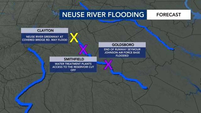
Neuse River
- Neuse River at Clayton: Has reached moderate flood stage (13 feet) but is expected to reach minor flood stage by 2 p.m. Friday.
- Potential impact: Neuse River Greenway flooding likely
- Neuse River at Goldsboro: Expected to reach moderate flood stage by 2 p.m. Friday.
- Potential impact: Flooding of Seymour-Johnson Air Force Base
- Neuse River at Smithfield: Has reached moderate flood stage but is expected to reach major flood stage by 2 p.m. Friday.
- Potential impact: Access could be cut off to water treatment plant
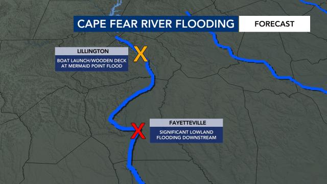
Cape Fear River
- Cape Fear River at Fayetteville: Expected to reach moderate flood stage by 2 a.m. Saturday, expected to drop below minor flood stage Monday.
- Potential impact: Significant lowland flooding downstream
- Cape Fear River at Lillington: Expected to drop below minor flood stage by 8 a.m. Saturday.
- Potential impact: The boat launch ramp and wooden deck at Mermaid
- Point Restaurant are flooded.
Lumber River
- Lumber River at Lumberton: At major flood stage (19 feet). Expected to reach moderate flood stage by 8 p.m. Sunday.
- Potential impact: Extensive flooding along the river. Over 50 homes or buildings inundated or isolated due to the flood waters. Several roads closed, especially in the Pines area and Cox Pond area. Carthage Road may be completely covered with water.
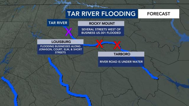
Tar River
- Tar River at Rocky Mount: Expected to drop below minor flood stage by 2 a.m. Sunday.
- Potential impact: Several streets west of Business U.S. 301 flooded
- Tar River at Louisburg: Has reached major flood stage and is expected to drop below minor flood stage by Sunday.
- Potential impact: Flooding to Johnston, Court, Elm and Short streets
- Tar River at Tarboro: Expected to reach moderate flood stage by 2 a.m. Sunday.
- Potential impact: River Road is underwater
Why do rivers flood after storms?
Flooding doesn’t just occur along North Carolina’s coast. Rivers flood too, and the worst flooding often occurs after a storm.
“As rain falls, it goes into the soil and then goes into the river,” WRAL meteorologist Chris Michaels explained. “This is why you’ll often see river levels rise to their highest levels days after the last rain drop falls.”
Tropical systems that affect our area typically have three threats that occur during different parts of the storm, according to WRAL meteorologist Elizabeth Gardner.
“Rain is typically the first thing to affect us with flash flooding,” Gardner said. “That’s where smaller streams like Crabtree Creek in Raleigh tend to flood for 24 hours or so, affecting the greenway and some car dealerships.”
Another threat is wind, which can cause trees to fall with damage and power outages.
“As the storm pulls away all the water moves from the smaller streams into the larger rivers which start to flood in the days after,” Gardner said. “As you would imagine the upstream towns flood first and the water continues to move downstream toward the coast.”
The Triangle is north of watersheds for larger eastern North Carolina rivers, including the Tar River, Neuse River and Cape Fear River. That means flooding is typically worse downstream of the Triangle.
“These rivers are large enough that major flooding can cause a good bit of damage to homes, businesses and farms as they flow toward the coast,” Gardner said. “We ended up with an average of 4 to 8 inches of rain from Debby, and that is causing minor to major flooding on some of our rivers.”
Get alerts when rivers flood with NC FIMAN
North Carolina’s Flood Inundation Mapping and Alert Network (FIMAN) map shows flooding forecasts from more than 500 gauges across the state so people can see if their area will be flooded during a particular storm.
People can click the alarm icon in the top right corner of the map to be notified if a river is flooding in their area.
The map also shows historical rainfall events that caused rivers to flood.
