- They couldn’t save their daughters’ lives in the July 4 floods. Now they’re dealing with the grief and the guilt.
- Austin could see heavy rains, possible flooding over the next few days
- Families of campers, counselors who died in Texas Hill County floods sue Camp Mystic
- Small plane bound for Jamaica with hurricane relief supplies crashes in Florida neighborhood
- Ask the Meteorologist: Did a tornado hit Johnston County Saturday night?
Forecast: Wind Advisory Tuesday; Extreme risk for wildfires tomorrow
Here are the latest updates from the KVUE Weather Impact Team.
AUSTIN, Texas — A Wind Advisory is in effect until 10 PM Tuesday for Llano, Burnet, Williamson, Travis, Milam, Lee, Bastrop, and Caldwell County*
Out-the-door conditions will be comfortable on Tuesday in Central Texas, with temperatures in the 50s and 60s areawide. Winds will be gusting out of the south, adding some humidity to the air today. This will be key to our lower fire risk.
Though no fire weather alerts are expected, caution is still advised. As of 11 AM, our Wind Advisory has expanded across the majority of Central Texas and will remain in effect until late tonight.
Overall, it’ll be a mostly sunny and warm afternoon, with highs in the mid 80s. Southerly flow will be sustained between 5-15 mph, with gusts from 20-35 mph.
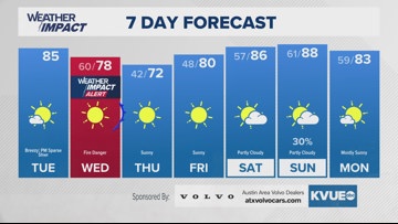
By Wednesday morning, another cold front will push through, which will once again increase the fire risk, with gusts up to 35-40 mph through the day. The KVUE Weather Team has issued a Weather Impact Alert Day on Wednesday due to “very high” to “extreme” fire danger. Afternoon temperatures will cool slightly behind the front, with a high in Austin around 78 degrees.
Looking ahead, temperatures will drop to the low 70s on Thursday, with lighter winds reducing fire concerns slightly. A warm-up starts this weekend, with temperatures climbing to 88 degrees by Sunday. A system late Sunday into Monday may bring some storm risk, which will be closely monitored.
SEVEN-DAY FORECAST:

Check out the live radar for what you can expect the rest of the day and into the workweek.