- Why no hurricanes made landfall in the US in 2025
- Florence to begin interviewing police chief finalists in January
- A West Texas county wants to better prepare for floods. Paying for it will be tricky.
- They couldn’t save their daughters’ lives in the July 4 floods. Now they’re dealing with the grief and the guilt.
- Austin could see heavy rains, possible flooding over the next few days
WRAL Severe Weather team forecasts "near-average" number of tropical systems in 2025
A lot of us don’t even want to think about hurricane season, especially since Debby and Helene did a number on North Carolina in 2024.
Helene was so destructive, the name will never be used again. Names are retired by the World Meteorological Organization when storms are more deadly and destructive (ie. Helene, Michael, Katrina, etc.).
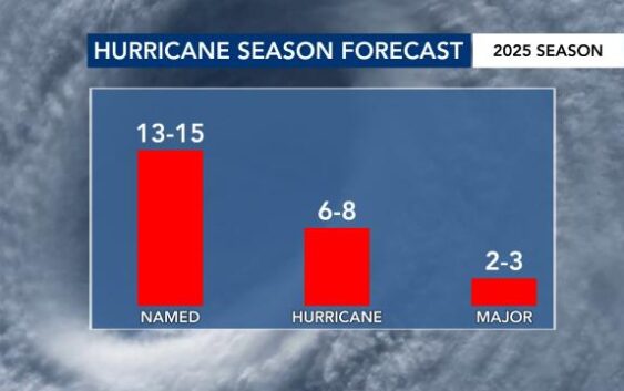
2025 Atlantic Hurricane Season Forecast
The WRAL Severe Weather team is forecasting a near-average number of systems this Atlantic hurricane season.
It means:
- 13-15 named storms
- Between six and eight storms are expected to become hurricanes
- Between two and three hurricanes would become Category 3 or higher (winds of 111 mph or higher)
The 2024 season had 18 named storms. Eleven became hurricanes, and five became major storms.
The numbers we are forecasting are just the number of storms that form within the Atlantic Basin. This stretches from the eastern coast of Mexico to the west coast of Africa.
The Atlantic hurricane season runs from June 1 to Nov. 30.
El Niño vs. La Niña
When making seasonal forecasts of any kind, we often refer to the El Niño Southern Oscillation. While this refers to the ocean temperatures off the coast of Peru, it is impactful downstream toward weather in the Atlantic.
During an El Niño, the wind above the surface becomes harsh and more disruptive to tropical systems. Therefore, you would expect fewer storms.

During a La Niña, the opposite is true. The wind above the surface is light and less disruptive to tropical systems. Therefore, you would expect more storms.

This year, the phase is expected to be neutral during the Atlantic hurricane season, which is part of why we expect the number of storms to closely match the climatological average.

Since 2000, North Carolina has seen a tropical system make landfall in 43% of neutral El Niño years.

Atlantic Ocean temperatures
Sea-surface temperatures are, perhaps, the most important part of forecasting hurricanes. Meteorologists Kat Campbell and Chris Michaels went to North Carolina State University, where Dr. Lian Xie taught that the critical temperature for tropical development is 80°F.
Currently, the sea-surface temperatures within the Atlantic’s Main Development Region [MDR] are below-average. The MDR is north of the Equator. Closer to home, however, the water is warmer which could lead to more “home-grown” storm systems.

The hope is that sub-average temperatures will continue within the Atlantic’s MDR during the peak of hurricane season, which runs from about Aug. 20 to Oct. 10.
The rise in tropical tornadoes in North Carolina
In 2024 alone, tropical systems were responsible for 31 tornadoes in North Carolina. That matches the annual average for twisters across the state.

Two of these tornadoes were EF-3, and they were both in our area. Debby produced an EF3 tornado in Lucama, and Helene produced an EF3 tornado in Rocky Mount.

This is becoming more of a long-term trend in North Carolina. Since 2000 and 2005, the average number of tropical tornadoes in the state has increased.

While inland flooding is the most deadly impact from a tropical system in North Carolina, the tornado threat is something that shouldn’t be ignored whenever we track tropical storms and hurricanes moving into the state.
What the WRAL Weather team will do
On WRAL.com and on WRAL News+, you will find daily video updates on the tropics. These will be updated depending on the amount of activity we’re seeing in the Atlantic Basin.
In terms of individual storms, the National Hurricane Center puts out updates at 2 a.m., 5 a.m., 8 a.m., 11 a.m., 2 p.m., 5 p.m., 8 p.m. and 11 p.m.
The updates that happen on the 5’s and 11’s are updates to the track, position and intensity.
The updates that happen on the 2’s and 8’s do not include adjustments to the storm’s track.