- They couldn’t save their daughters’ lives in the July 4 floods. Now they’re dealing with the grief and the guilt.
- Austin could see heavy rains, possible flooding over the next few days
- Families of campers, counselors who died in Texas Hill County floods sue Camp Mystic
- Small plane bound for Jamaica with hurricane relief supplies crashes in Florida neighborhood
- Ask the Meteorologist: Did a tornado hit Johnston County Saturday night?
Risk of severe weather across Charlotte area on Friday
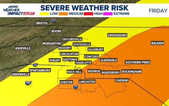
CHARLOTTE, N.C. — A Weather Impact Alert has been issued for Friday afternoon as a line of thunderstorms is expected to sweep across the Carolinas with the threat of severe weather, including damaging winds and hail.
Weather Impact Meteorologist Chris Mulcahy says the storms will push into the Charlotte area by 1 p.m. on Friday, May 30. The window for when these storms are expected to impact the Charlotte metro extends from 1 p.m. until 5 p.m. on Friday. Some pop-up storms could arrive after this, but the main threat will be until 5 p.m.
Mulcahy says the biggest risk with these storms will be heavy rain and strong winds. There could be some isolated supercells capable of producing hail and damaging winds.
This Friday afternoon has the best chance for a severe thunderstorm as a pre-frontal line of storms is possible. Chance for a line of storms and even single supercells. A lot can still chance and the severity threat will be more clear by tomorrow morning! @wcnc Stay Weather Aware pic.twitter.com/w1IpWKaqQk
— Chris Mulcahy (@YOURWEATHERMAN) May 28, 2025