- Eric Tulsky comfortable, confident and going for the Stanley Cup in 2nd year as Hurricanes GM
- 5 homes collapse into the surf of the Outer Banks as hurricanes rumble in Atlantic
- As hurricanes pass offshore, more Buxton homes collapse into the sea
- Central Texas floods reveal need to shore up disaster response in unincorporated areas
- Latest: Tropical Storm Imelda will pull away from East Coast, expected to become a hurricane
Weather Impact Alert: Gusty, damaging winds possible Saturday with isolated storms
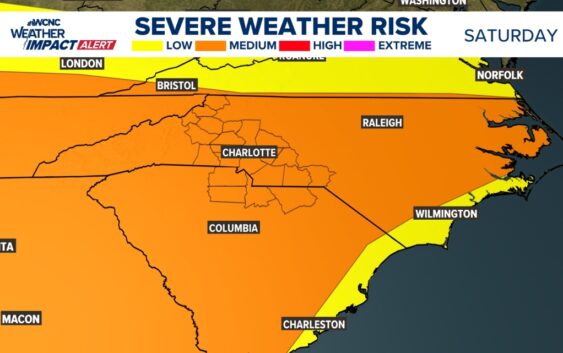
Even though there won’t be many storms this weekend, the ones that do form will bring gusty winds and heavy rain.
CHARLOTTE, N.C. — Welcome to summertime in the Carolinas – where most days have at least a small risk for strong storms. Saturday will be one of those days.
Multiple waves of storms will move across the Southeast this weekend. With plenty of storm fuel due to high temperatures near 90 degrees, the severe weather risk is trending upward.
The main impact would be damaging winds of 60+ mph with some small hail. Heavy rain and lightning are also expected. The highest chance for storms on Saturday is late afternoon into the evening hours. We will have a better timeline by Friday.
Not everyone in the Charlotte area will see storms. However, the storms that do develop have severe potential.
The best way to prepare is by downloading the WCNC Charlotte mobile app and staying tuned for any weather changes. If severe weather does strike, we will stream on WCNC+.
Contact Brittany Van Voorhees at bvanvoorhe@wcnc.com and follow her on Facebook, X and Instagram.