- They couldn’t save their daughters’ lives in the July 4 floods. Now they’re dealing with the grief and the guilt.
- Austin could see heavy rains, possible flooding over the next few days
- Families of campers, counselors who died in Texas Hill County floods sue Camp Mystic
- Small plane bound for Jamaica with hurricane relief supplies crashes in Florida neighborhood
- Ask the Meteorologist: Did a tornado hit Johnston County Saturday night?
Weather Impact Alert: Brad Panovich updates risk of severe weather Monday evening
The WCNC Charlotte Weather Impact Team is keeping you weather aware as there could be multiple lines of severe storms across the Carolinas on Monday.
CHARLOTTE, N.C. — The WCNC Charlotte Weather Impact Team is issuing a Weather Alert due to the threat of strong-to-severe thunderstorms in the Charlotte area, particularly for Charlotte and areas south of the Queen City, Monday evening into early Tuesday.
These storms have had a major impact on the Southeast as they race toward the Carolinas and by Monday evening, there’s a chance for isolated to scattered thunderstorms into the overnight hours.
NOTE: The Carolinas are not highlighted as a primary area of concern in this forecast by the Storm Prediction Center. The main severe weather threats are focused on the Ohio Valley, Great Lakes region, and areas from the lower Mississippi Valley into the eastern Gulf Coast. Any impacts on the Carolinas would likely be secondary effects or the tail end of weather systems affecting other regions.
When
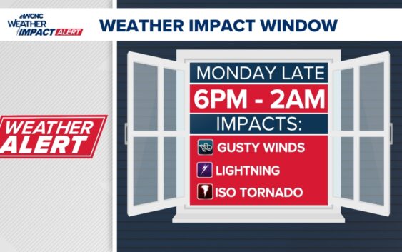
There’s not a general time everyone can expect to be impacted due to the scattered nature of these storms. However, meteorologist Chris Mulcahy says everyone in the Charlotte area should be prepared for potentially severe weather from 6 p.m. until around 2 a.m. Tuesday.
“If I were to give you a specific time, it’s hard to do, because we don’t know when and how the storms will unfold,” Chief Meteorologist Brad Panovich said. “I really think dinner time and beyond, so 5, 6 or 7 o’clock and then 8, 9, 10 o’clock, they could linger.”
With many people asleep around this time, we want you to be especially weather aware. Please make sure to have multiple ways to get warnings if the weather impacts you.
Impact
Panovich believes the most dangerous conditions are expected south of Interstate 40, particularly areas from Charlotte and southward into South Carolina. Monday’s storms could be another blow for the Midlands of South Carolina, which have been hit repeatedly by severe weather.
Panovich says the highest risk will be straight-line winds.
“Primarily, we’re worried about the wind,” he said. “We’ve got a lot of wind energy in the mid-levels of the atmosphere. Those are really strong winds. And when you see that in the mid-levels, and you have dry air, you can mix down really strong winds.”
- The highest threat is for gusty winds
- The lowest threat is for large hail
- There is a very low but slight chance for a spin-up tornado later this evening before midnight.
- Heavy rain and of course, dangerous, frequent lightning are always threats in any thunderstorm.
Need
- Watch your radar for storms mid to late evening, especially
- Have WCNC+ downloaded. This is the best tool to have since our live content will also stream on our WCNC app.
- Stay Weather Aware through this evening and going to bed. This is a low chance and relies on how that MCS (Mesoscale Convective System) will behave this afternoon which will dictate our status.
Stay connected to the WCNC Charlotte Weather Team
Contact Brad Panovich at bpanovich@wcnc.com or follow him on Facebook, X and Instagram.
Contact Bekah Birdsall at rbirdsall@wcnc.com and follow her on Facebook, X and Instagram.
Contact Chris Mulcahy at cmulcahy@wcnc.com and follow him on Facebook, X, Instagram, and TikTok.
Contact Majestic Storm at majesticstorm@wcnc.com and follow her on Facebook, X and Instagram.
Contact Brittany Van Voorhees at bvanvoorhe@wcnc.com and follow her on Facebook, X and Instagram.