- They couldn’t save their daughters’ lives in the July 4 floods. Now they’re dealing with the grief and the guilt.
- Austin could see heavy rains, possible flooding over the next few days
- Families of campers, counselors who died in Texas Hill County floods sue Camp Mystic
- Small plane bound for Jamaica with hurricane relief supplies crashes in Florida neighborhood
- Ask the Meteorologist: Did a tornado hit Johnston County Saturday night?
Weather Impact Alert: Damaging winds, downpours expected across the Houston area this afternoon
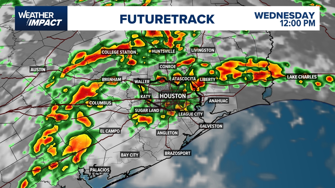
Houston could see strong downpours and scattered thunderstorms from late morning through mid afternoon Wednesday
HOUSTON — Wednesday will bring another day with widespread showers and thunderstorms. Rain chances ramp up quickly mid to late morning and last through the late afternoon.
Weather Impact Alert
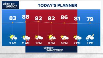
The KHOU 11 Weather Team has issued an hourly Weather Impact Alert as storm chances ramp up after 11 a.m., with the highest risk of severe weather between 1 p.m. and 7 p.m.
Temperatures will peak near 88° midday, and scattered thunderstorms, some severe, are expected during the afternoon commute.
Stay weather-aware during the evening as storms could linger into the early nighttime hours.

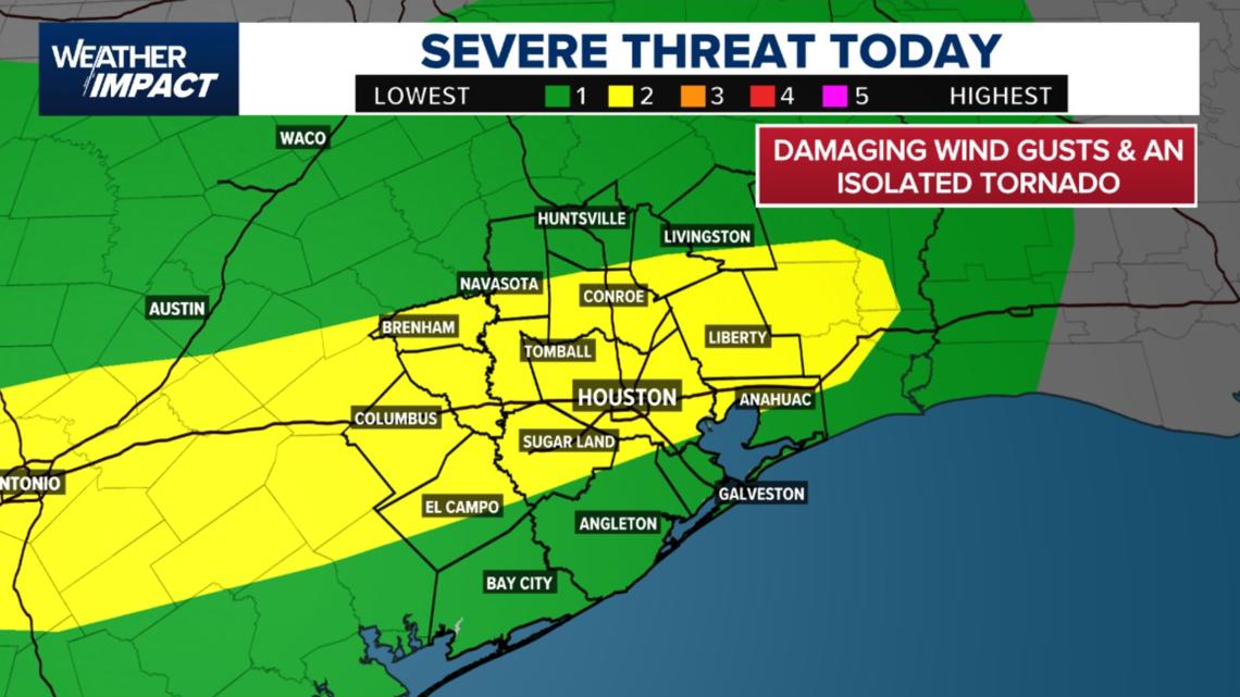
Severe storm risk: Damaging winds, isolated tornado possible
A Level 2 out of 5 (Slight Risk) has been issued for much of Southeast Texas, including Houston, Sugar Land, Tomball, Conroe, Liberty, and El Campo. This means there’s an elevated risk for damaging wind gusts and a potential isolated tornado, especially during the afternoon and evening hours.
Threats include:
- Damaging wind gusts
- Isolated tornado
- Heavy downpours leading to street flooding

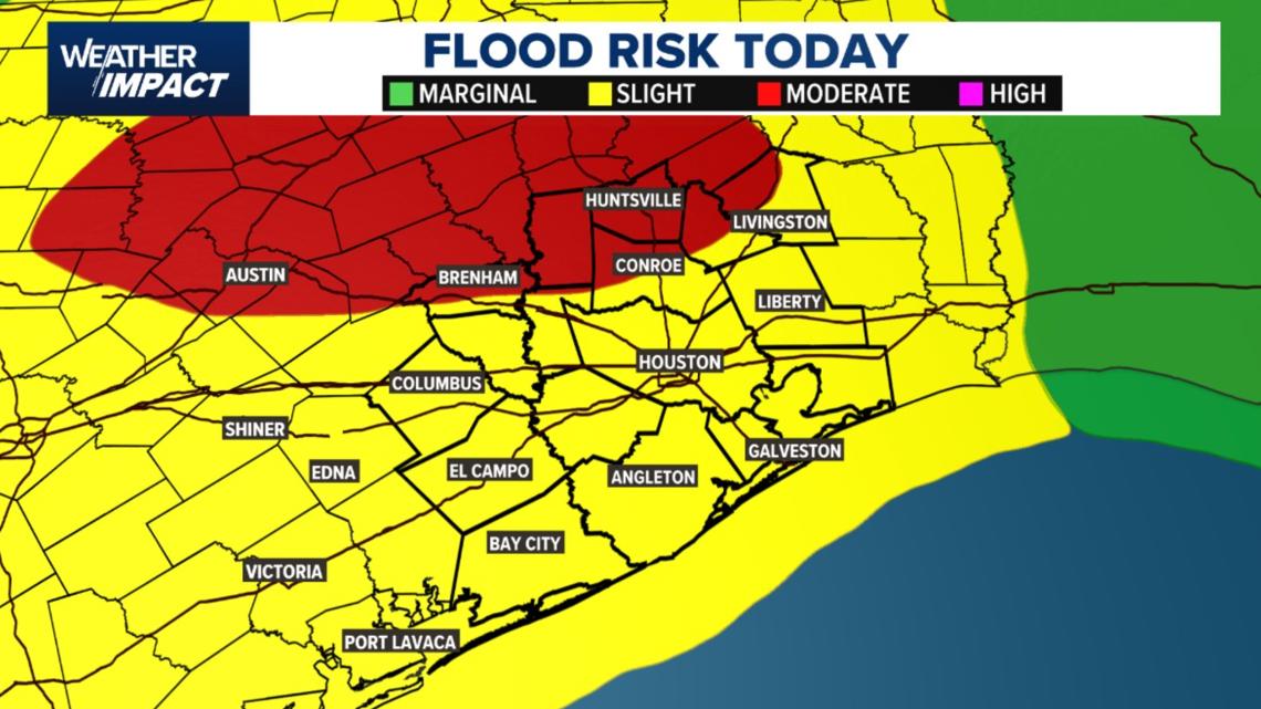
Flooding risk expands across Southeast Texas
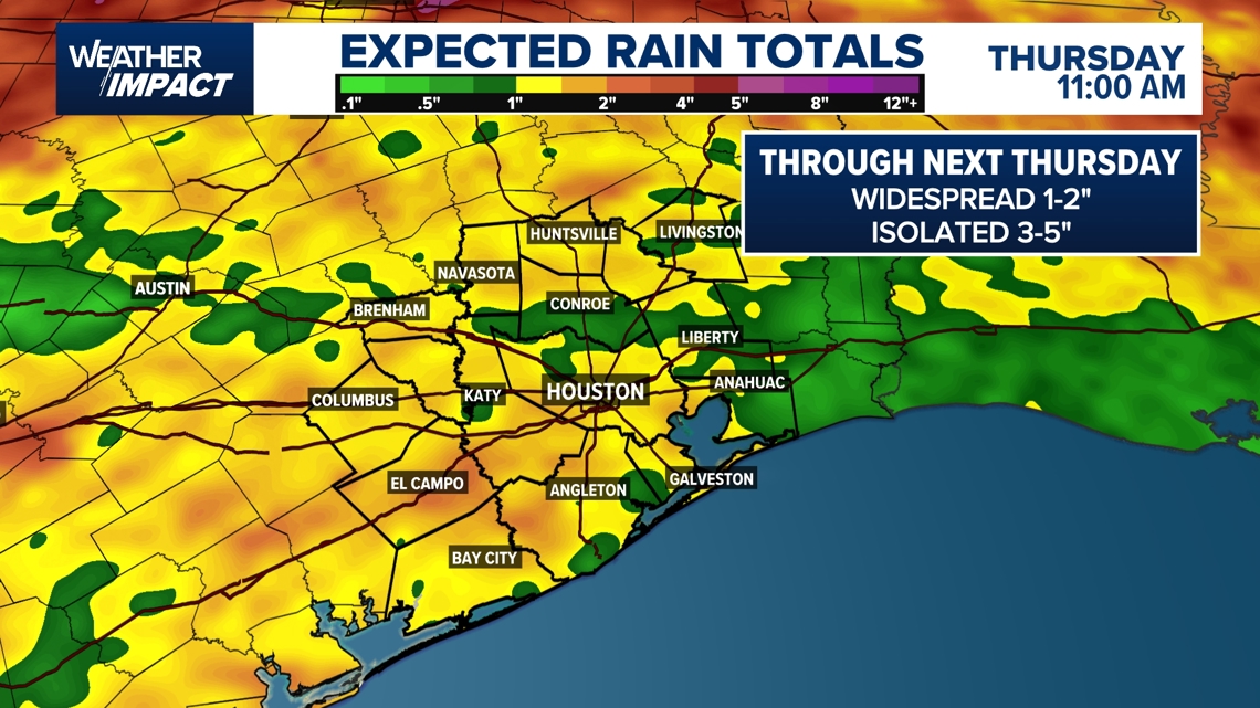
A slight flood risk extends across the Houston metro area today, with moderate risk zones further north and west, including Brenham, Huntsville, and Austin. Storms this afternoon could bring heavy downpours, especially to already saturated areas, raising the risk of street flooding and low-lying water accumulation.

Timing the storms
Expect a mostly dry morning. The first round of storms should begin between 1 p.m. and 7 p.m., with scattered thunderstorms likely across the area into the early evening.
Expect two rounds of storms today:
- Mid to late morning (10 a.m. – noon): Initial round of showers and thunderstorms begins to develop.
- Afternoon to early evening (Noon – 7 p.m.): A second, stronger round is likely, coinciding with the afternoon commute.
- Evening (through 9–10 p.m.): Storms may linger in isolated areas before tapering off.
Thursday morning: Rain returns early along the coast, spreading inland by the commute. Conditions may not fully wind down until later in the day.

Areas most at risk
- Entire Houston metro is under a Level 2 risk for severe storms.
- Northwest of Houston (e.g., Wharton, Columbus, north of Katy): May see the first signs of morning activity.
- South and coastal areas (e.g., Galveston, Pearland): Could see evening storms as activity shifts southward.

What you should do
- Prep early: Run errands before 10 a.m. to avoid storm activity.
- Watch for flooded roads: Street flooding is possible during and after downpours.
- Secure outdoor items: Strong wind gusts could knock down unsecured objects.
- Stay alert: Keep notifications on for watches or warnings. Conditions could escalate quickly.
“Don’t drive through flooded roads. You know the drill — we’ve done this before,” says KHOU 11 Meteorologist Pat Cavlin.
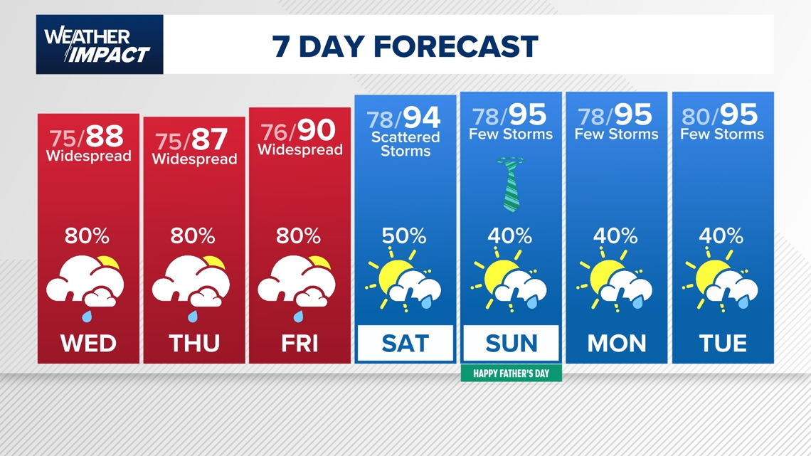
Looking ahead: More rain, then heat
- Thursday: Another weather alert day. Expect widespread rain with 2–4 inches likely and isolated totals up to 6–8 inches.
- Friday: Less active but still scattered showers.
- Weekend: Drier breaks with heat returning early next week.
- Tropics: No storm development expected over the next 7 days.
- Father’s Day (Sunday) is trending drier but still warm.

Counties we serve:
Harris County (including Houston, Pasadena, Baytown), Fort Bend County (Richmond, Sugar Land, Missouri City), Montgomery County (Conroe, The Woodlands), Brazoria County (Angleton, Pearland, Alvin, Lake Jackson), Galveston County (Galveston, League City, Texas City), Liberty County (Liberty, Cleveland, Dayton), Walker County (Huntsville, New Waverly), Waller County (Hempstead, Prairie View, Waller), Polk County (Livingston, Corrigan), Chambers County (Anahuac, Mont Belvieu, Winnie), Wharton County (Wharton, El Campo), Washington County (Brenham), Matagorda County (Bay City, Palacios), Grimes County (Anderson, Navasota), Austin County (Bellville, Sealy), Colorado County (Columbus, Eagle Lake, Weimar), Trinity County (Groveton, Trinity).