- They couldn’t save their daughters’ lives in the July 4 floods. Now they’re dealing with the grief and the guilt.
- Austin could see heavy rains, possible flooding over the next few days
- Families of campers, counselors who died in Texas Hill County floods sue Camp Mystic
- Small plane bound for Jamaica with hurricane relief supplies crashes in Florida neighborhood
- Ask the Meteorologist: Did a tornado hit Johnston County Saturday night?
Weather Impact Alert: Damaging winds, heavy downpours expected across the Houston area
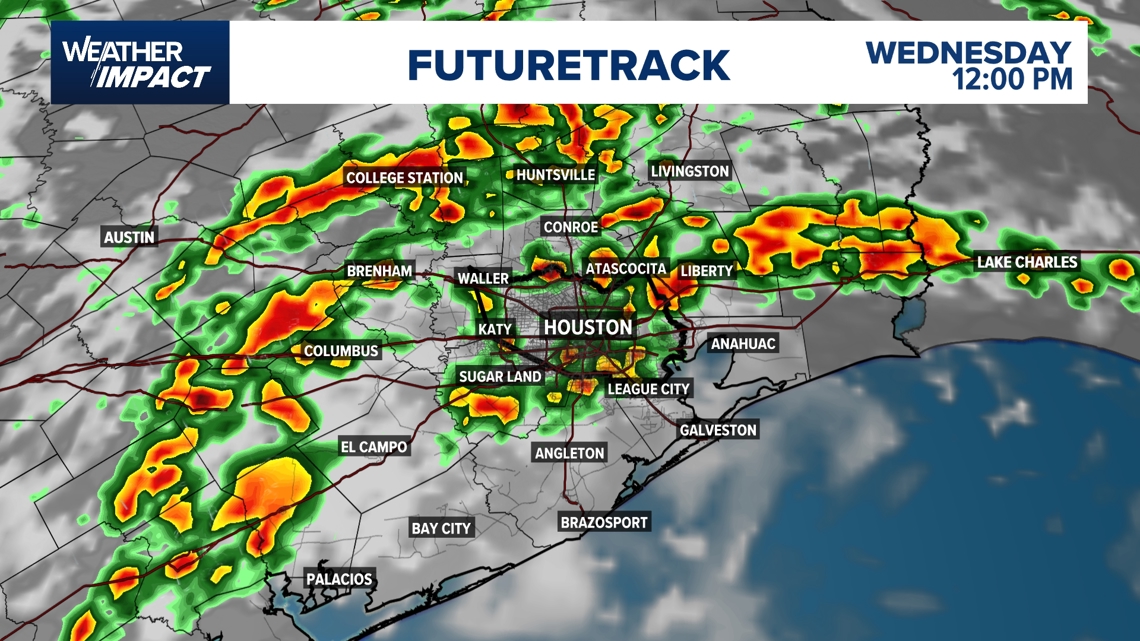
Houston could see strong downpours and scattered thunderstorms from late morning through mid afternoon Wednesday
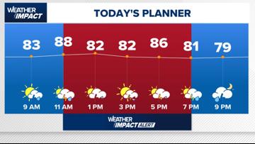
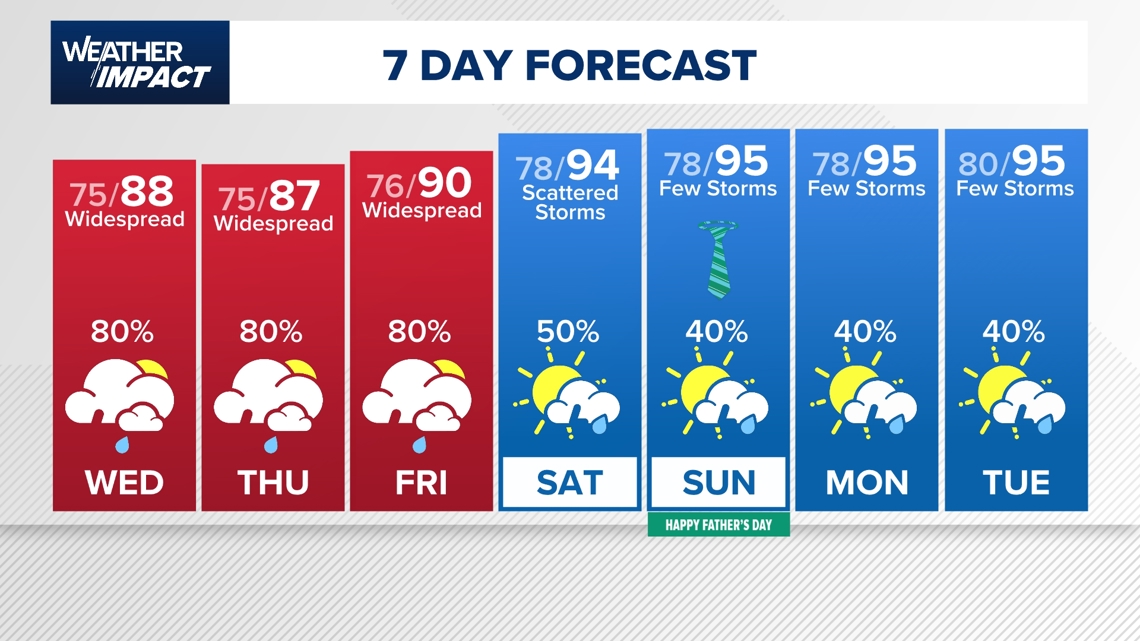
HOUSTON — Wednesday will bring another day with widespread showers and thunderstorms. Rain chances ramp up quickly mid to late morning and last through the late afternoon.
Weather Impact Alert
The KHOU 11 Weather Team has issued an hourly Weather Impact Alert as storm chances ramp up after 11 a.m., with the highest risk of severe weather between 1 p.m. and 7 p.m.
Temperatures will peak near 88° midday, and scattered thunderstorms, some severe, are expected during the afternoon commute.
Stay weather-aware during the evening as storms could linger into the early nighttime hours.

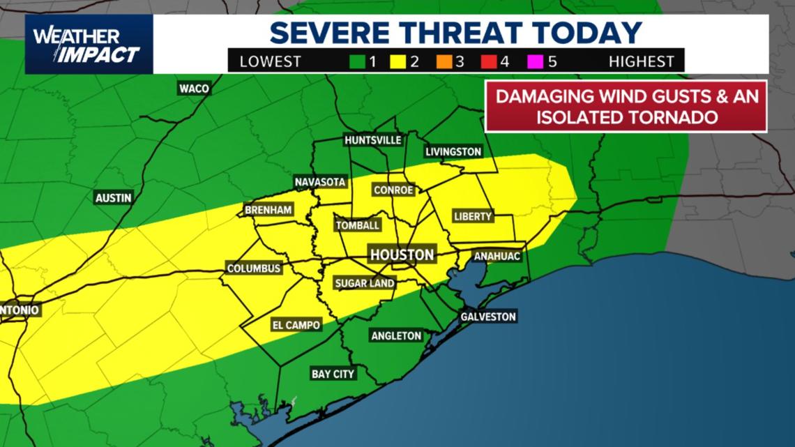
Severe storm risk: Damaging winds, isolated tornado possible
A Level 2 out of 5 (Slight Risk) has been issued for much of Southeast Texas, including Houston, Sugar Land, Tomball, Conroe, Liberty, and El Campo. This means there’s an elevated risk for damaging wind gusts and a potential isolated tornado, especially during the afternoon and evening hours.

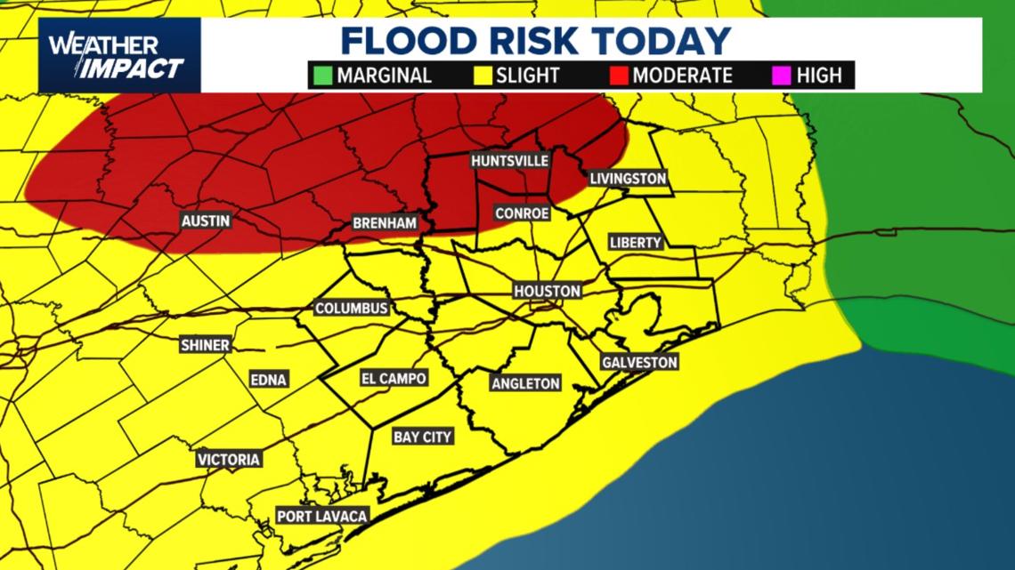
Flooding risk expands across Southeast Texas
A slight flood risk extends across the Houston metro area today, with moderate risk zones further north and west, including Brenham, Huntsville, and Austin. Storms this afternoon could bring heavy downpours, especially to already saturated areas, raising the risk of street flooding and low-lying water accumulation.

Timing the storms
Expect a mostly dry morning. The first round of storms should begin between 1 p.m. and 7 p.m., with scattered thunderstorms likely across the area into the early evening.
Storm timeline:
- Morning: Dry and quiet start from sunrise through mid-morning
- 10 AM – 11 AM: Scattered storms begin to blossom across the area
- NOON – 4 PM: Stronger cells possible, isolated hail or wind gusts
- Evening: Storms taper off but may linger in isolated spots

Areas most at risk
While no specific counties are singled out for higher risk, initial storms may develop northwest of Houston, with impacts gradually spreading across the metro area.
- North of I-10: Early storm development is likely
- Coastal and southern areas: May see storms later in the afternoon

What you should do
- Use the dry morning to prep: Run errands and travel early if possible
- Watch for ponding: Especially by midweek when the ground will already be saturated
- Secure outdoor items: Gusty winds could accompany stronger cells
- Stay weather aware: Keep alerts enabled and check live radar updates throughout the day
No watches or warnings are currently active, but that could change if storms intensify.
Looking ahead: Wetter days coming
Today’s scattered activity is just the warm-up.
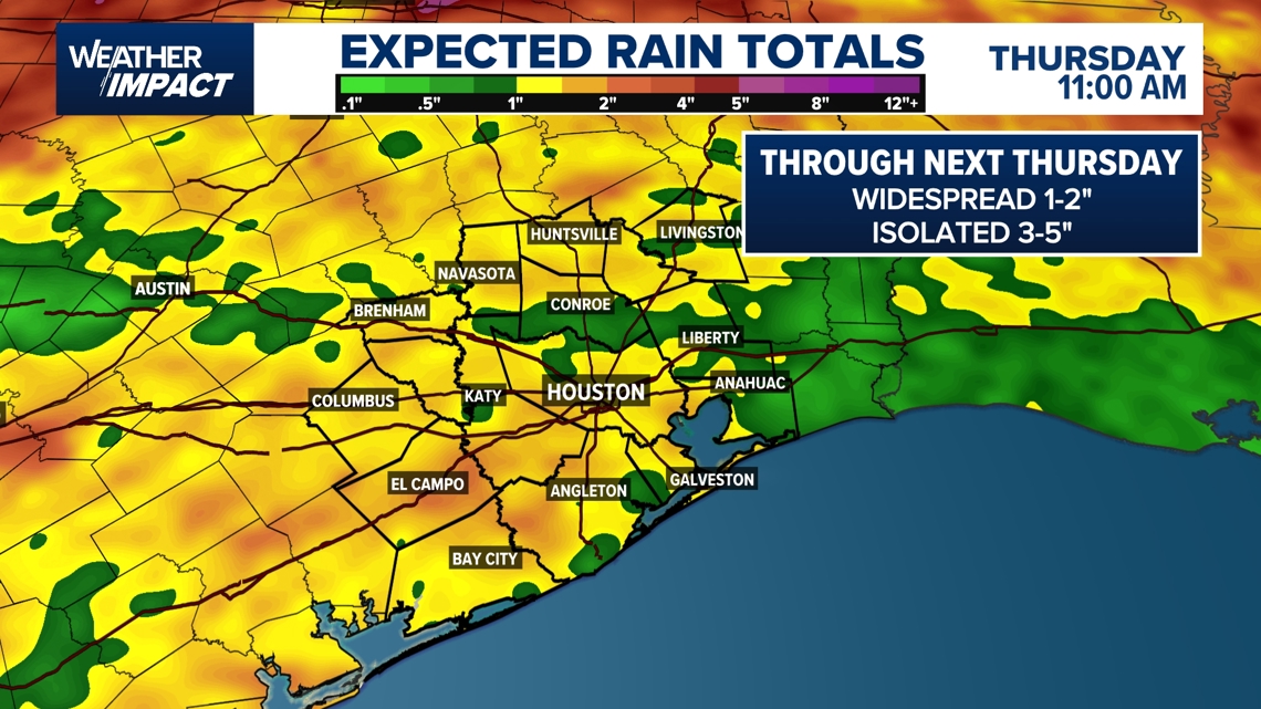
- Wednesday & Thursday: Expect widespread downpours and higher rain totals — 2 to 3 inches area-wide, with isolated spots picking up 3 to 5 inches
- Flood risk: Could increase midweek due to already saturated ground
- Friday into the weekend: Still rainy, but totals expected to be lower with occasional breaks
Temperatures will hover in the upper 80s to low 90s, depending on storm timing each day.

Counties we serve:
Harris County (including Houston, Pasadena, Baytown), Fort Bend County (Richmond, Sugar Land, Missouri City), Montgomery County (Conroe, The Woodlands), Brazoria County (Angleton, Pearland, Alvin, Lake Jackson), Galveston County (Galveston, League City, Texas City), Liberty County (Liberty, Cleveland, Dayton), Walker County (Huntsville, New Waverly), Waller County (Hempstead, Prairie View, Waller), Polk County (Livingston, Corrigan), Chambers County (Anahuac, Mont Belvieu, Winnie), Wharton County (Wharton, El Campo), Washington County (Brenham), Matagorda County (Bay City, Palacios), Grimes County (Anderson, Navasota), Austin County (Bellville, Sealy), Colorado County (Columbus, Eagle Lake, Weimar), Trinity County (Groveton, Trinity).