- They couldn’t save their daughters’ lives in the July 4 floods. Now they’re dealing with the grief and the guilt.
- Austin could see heavy rains, possible flooding over the next few days
- Families of campers, counselors who died in Texas Hill County floods sue Camp Mystic
- Small plane bound for Jamaica with hurricane relief supplies crashes in Florida neighborhood
- Ask the Meteorologist: Did a tornado hit Johnston County Saturday night?
Forecast: Drying out through Thursday after heavy rain and severe weather overnight
Here are the latest updates from the KVUE Weather Impact Team.
Jordan Darensbourg, Hunter Williams, Grace Thornton, KC Sherman
11:46 AM CST March 6, 2019
9:05 AM CDT June 12, 2025
AUSTIN, Texas — Central Texas had a very active night of weather overnight Wednesday into early Thursday morning.
A tornado was confirmed just south of Wimberly, which happened around 1 AM Thursday morning. Additionally, multiple Flash Flood Warnings were issued, with some areas picking up totals of 2 to 4 inches of rain.
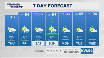
After Thursday morning’s round of rain and storms, a drying trend will begin for Thursday afternoon, leaving us much quieter for Friday into the weekend. Thursday afternoon’s rain chances will drop down to around a 20% chance, with just an isolated storm possible for the afternoon. Temperatures will remain below average in the middle to upper 80s under a mainly cloudy sky.
Friday will continue to bring us quieter conditions, with just a chance of an isolated storm. Highs will rebound back into the middle 90s.
Father’s Day weekend won’t be completely dry, but rain chances will only range from 20 to 30 percent. Highs will remain at and above seasonable levels, with temperatures set to warm into the middle 90s.
The KVUE Weather Team will keep a close eye on this system. Stay tuned for updates, and check out the full extended forecast below.
