- Eric Tulsky comfortable, confident and going for the Stanley Cup in 2nd year as Hurricanes GM
- 5 homes collapse into the surf of the Outer Banks as hurricanes rumble in Atlantic
- As hurricanes pass offshore, more Buxton homes collapse into the sea
- Central Texas floods reveal need to shore up disaster response in unincorporated areas
- Latest: Tropical Storm Imelda will pull away from East Coast, expected to become a hurricane
Weather Impact Alert: Roads flooding, flights delayed in Houston thunderstorms, downpours
A ground stop was reported at Bush Airport due to thunderstorms.
HOUSTON — The KHOU 11 weather team has called for a Weather Impact Alert this afternoon.
Happening now
A Flood Advisory is in effect for central and northern parts of Harris County—including areas like Aldine, Memorial Park, River Oaks, Greenspoint, and Spring Branch—through 5 p.m. Heavy rain from thunderstorms has already dropped 1 to 2 inches in the area, and another 1 to 2 inches is possible. Minor flooding is expected in low-lying spots and urban areas with poor drainage. Use caution and avoid flooded roadways.
A cluster of strong thunderstorms was moving north at 10 mph near Spring as of 3:06 p.m., prompting a Special Weather Statement for parts of Montgomery, Liberty, and Harris counties. Gusty winds up to 40 mph and pea-size hail are possible. Areas that may be impacted include Humble, Kingwood, Splendora, Porter, and the Lake Houston area. Expect minor hail damage and the potential for downed tree limbs.
A ground stop was reported at George Bush Intercontinental Airport until 4 p.m. due to thunderstorms. The grounding applied to departures from Bush.
What to expect
While we aren’t under a formal Severe Weather Risk (SPC level) today, locally heavy downpours and isolated thunderstorms are possible across the Houston area.
Main concerns today:
- Brief heavy rain
- Isolated thunderstorms
- Localized street flooding in poor drainage areas
This unsettled pattern is typical for late June in Houston, and while annoying, it’s helping keep drought conditions at bay before next week’s heat sets in.
Timing
Late morning to afternoon (Through 4 p.m.)
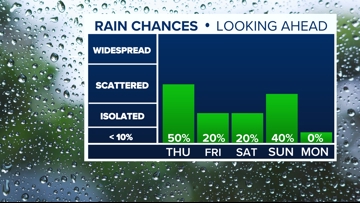
- Rain coverage increases. Peak rain chance: 50% around midday. Some storms could linger into the afternoon with a 40% chance through 4 p.m.
- Storms taper off by early evening. Overnight looks mostly dry but muggy.
Friday Outlook
- Lower rain chances (20-30%), but still a few pop-up showers possible.
Geographic impact
Most at risk:
- Areas south and southeast of I-10 likely to see the first and heaviest downpours due to moisture moving in from the Gulf.
Later impacts:
- Rain spreads north toward inland communities, but rainfall totals should remain lighter in far northern counties.
Key zones to watch:
- Galveston, coastal Harris County, southeast suburbs, and anywhere from southwest Harris County toward Fort Bend County for slightly higher accumulations.
What you should know
- Keep umbrellas and rain gear handy, especially through early afternoon.
- Watch for brief street flooding in poor drainage spots.
- Be prepared for muggy conditions even after the rain ends.
No current alerts, watches, or warnings, but stay weather-aware as isolated heavy downpours could create brief traffic issues.

Looking ahead
The weekend:
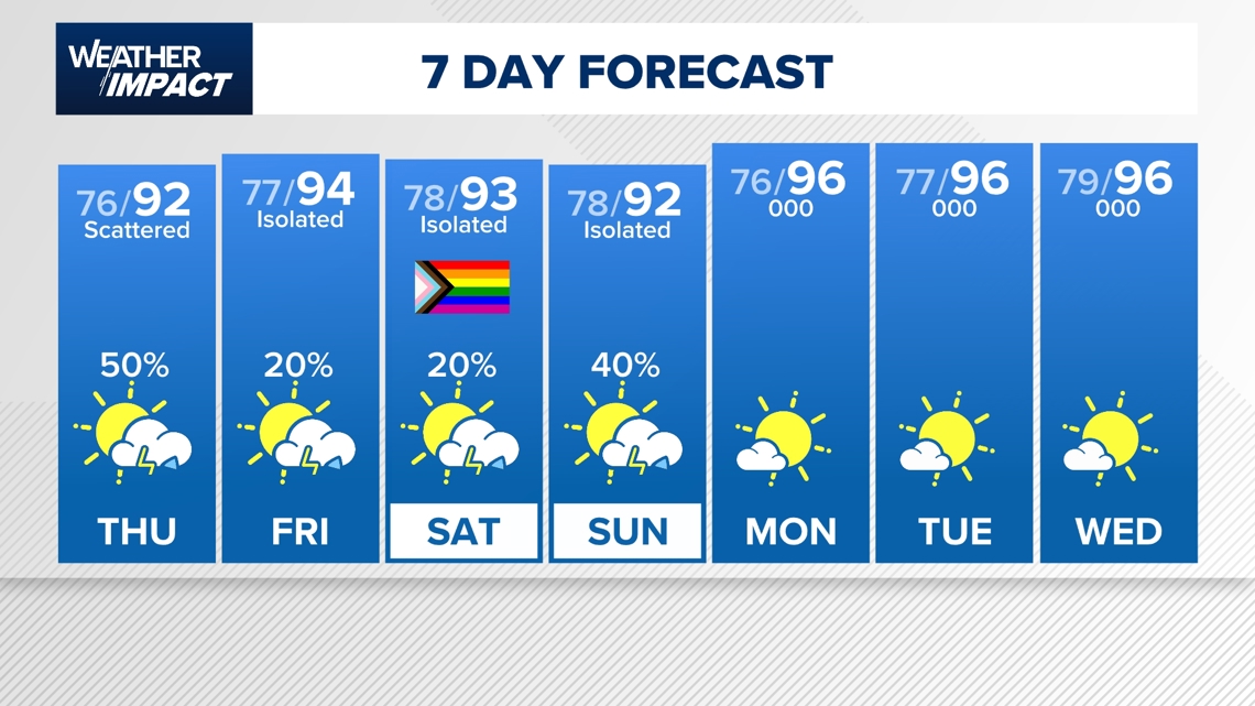
- Expect a major pattern shift with hotter, drier weather and highs in the mid to upper 90s starting Monday.
- A Saharan dust plume could also move into southeast Texas by July 1, bringing hazy skies and helping to limit tropical development for now.
Next week and 4th of July:
- Rain chances lessen with mostly sunny skies. It is not out of the question for isolated showers on some days.
- Afternoon highs will ramp up, reaching the upper 90s.
- Expecting our next push of Saharan dust next week.

Counties we serve:
Harris County (including Houston, Pasadena, Baytown), Fort Bend County (Richmond, Sugar Land, Missouri City), Montgomery County (Conroe, The Woodlands), Brazoria County (Angleton, Pearland, Alvin, Lake Jackson), Galveston County (Galveston, League City, Texas City), Liberty County (Liberty, Cleveland, Dayton), Walker County (Huntsville, New Waverly), Waller County (Hempstead, Prairie View, Waller), Polk County (Livingston, Corrigan), Chambers County (Anahuac, Mont Belvieu, Winnie), Wharton County (Wharton, El Campo), Washington County (Brenham), Matagorda County (Bay City, Palacios), Grimes County (Anderson, Navasota), Austin County (Bellville, Sealy), Colorado County (Columbus, Eagle Lake, Weimar), Trinity County (Groveton, Trinity).