- They couldn’t save their daughters’ lives in the July 4 floods. Now they’re dealing with the grief and the guilt.
- Austin could see heavy rains, possible flooding over the next few days
- Families of campers, counselors who died in Texas Hill County floods sue Camp Mystic
- Small plane bound for Jamaica with hurricane relief supplies crashes in Florida neighborhood
- Ask the Meteorologist: Did a tornado hit Johnston County Saturday night?
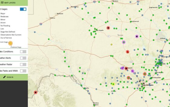
Track flash flooding in real time across Texas with these two maps
See updated flood zones and road conditions amid Kerrville and Hill Country flash flooding.
TEXAS, USA — As emergency crews respond to catastrophic flooding in Kerrville and the Hill Country region, two interactive maps can help residents and families track real-time flood levels and road closures across affected parts of Texas.
For full coverage on flooding impacts, evacuations, and rescue operations in Kerrville and the Hill Country, read our latest updates here.
Live flood map
Provided by the Texas Water Development Board
What it shows:
- River gauge levels
- Flash flood alerts
- High water crossings
How to use: Zoom into your area or search by county. Use the legend to toggle specific markers like water gauge levels and flood stages.
Road closures & traffic map
From the Texas Department of Transportation
What it shows:
- Road closures
- Travel hazards
- Detours and construction
How to use: Zoom into your route or area of concern. Click on icons or lines for live closure details reported by TxDOT.
Why it matters
The Guadalupe River rose more than 20 feet in just four hours overnight in Kerrville, prompting mandatory evacuations, disaster declarations, and multiple water rescues.
Local officials say this flood has surpassed the infamous 1987 flood, which killed 10 teenagers at a church camp.
At least six people have died so far, and many roads across Kerr, Kendall, and Bandera counties remain impassable due to flash flooding and debris.
Stay informed
- Evacuation and reunification centers have been opened in Kerrville and Ingram.
- Residents are being urged to shelter in place and avoid driving.
- Camps along the Guadalupe River are being monitored, but some campers are still being accounted for.
Officials say more rain is in the forecast, and flooding could worsen.