- They couldn’t save their daughters’ lives in the July 4 floods. Now they’re dealing with the grief and the guilt.
- Austin could see heavy rains, possible flooding over the next few days
- Families of campers, counselors who died in Texas Hill County floods sue Camp Mystic
- Small plane bound for Jamaica with hurricane relief supplies crashes in Florida neighborhood
- Ask the Meteorologist: Did a tornado hit Johnston County Saturday night?
Forecast: Flood Watch continues into Sunday; Hill Country at risk for additional flooding
Here are the latest updates from the KVUE Weather Impact Team.
Jordan Darensbourg, Hunter Williams, Grace Thornton, KC Sherman
11:46 AM CST March 6, 2019
10:59 PM CDT July 5, 2025
AUSTIN, Texas — A Weather Impact Alert Day has been issued for Saturday due to heavy rain and flash flooding.
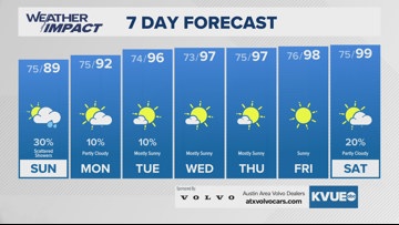
Dry conditions will take over for a short while tonight, but the return of scattered downpours is expected for Sunday in select spots. The Flood Watch in Central Texas has been extended through 1 p.m. Sunday.
The remnant low will be shifting west during this time, increasing the flood threat throughout the Texas Hill Country on Sunday. We could see additional inches of rain in Mason, Gillespie, and Llano County, and we need to monitor the Llano River and Pedernales Rivers and surrounding streams for potential flash flooding, too.
Thankfully, drier weather will work its way back into Central Texas for the beginning of the work week, but a few isolated rains will still be possible through Tuesday. Hotter and drier trends continue through the middle and end of next week.
The KVUE weather team will continue to keep you updated on any changes. Here’s the full 7-day forecast below:
