- They couldn’t save their daughters’ lives in the July 4 floods. Now they’re dealing with the grief and the guilt.
- Austin could see heavy rains, possible flooding over the next few days
- Families of campers, counselors who died in Texas Hill County floods sue Camp Mystic
- Small plane bound for Jamaica with hurricane relief supplies crashes in Florida neighborhood
- Ask the Meteorologist: Did a tornado hit Johnston County Saturday night?
Forecast: Flood Watch continues through Monday; Isolated flash flooding remains possible
Here are the latest updates from the KVUE Weather Impact Team.
Jordan Darensbourg, Hunter Williams, Grace Thornton, KC Sherman
11:46 AM CST March 6, 2019
7:28 AM CDT July 7, 2025
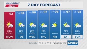
AUSTIN, Texas — Central Texas weather has been the talk of the country this holiday weekend, and unfortunately, our wet weather is not expected to come to a close until the middle of next week.
For Monday, there is still a Flood Watch in effect through 7 p.m., covering a majority of the KVUE viewing area. For this reason, a Weather Impact Alert Day has been declared through Monday evening. Additional areas of isolated flash flooding will remain possible as additional showers and storms redevelop across the area. Rainfall rates of 1″-3″ will be possible, which will only aggravate are already super-soaked soils and could lead to the fast redevelopment of flooding in some spots.
With the small upper-level area of low pressure that produced this weekend’s deadly flooding hanging around through Monday and most of Tuesday, more rain and storms, with heavy downpours will remain in the forecast through midweek. An additional disturbance tracking into the coast of Texas on Wednesday will bring another chance for some rain, before drier conditions return Thursday and Friday.
The KVUE weather team will continue to keep you updated on any changes. Here’s the full seven-day forecast below:
