- They couldn’t save their daughters’ lives in the July 4 floods. Now they’re dealing with the grief and the guilt.
- Austin could see heavy rains, possible flooding over the next few days
- Families of campers, counselors who died in Texas Hill County floods sue Camp Mystic
- Small plane bound for Jamaica with hurricane relief supplies crashes in Florida neighborhood
- Ask the Meteorologist: Did a tornado hit Johnston County Saturday night?
'We're running out of beach': NC Highway 12 remains open as Outer Banks braces for Hurricane Erin
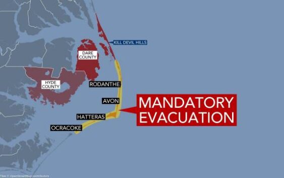
Hurricane Erin has prompted mandatory evacuations in the Outer Banks.
Avon, Kill Devil Hills, Hatteras Island, Ocracoke Island and Rodanthe are under mandatory evacuations along with Dare and Hyde counties. More than 1,000 people left the Outer Banks on Monday.
Storm surge flooding and tropical storm conditions are expected in the Outer Banks late Wednesday. The Outer Banks could see waves between 15 and 20 feet.
Dare County leaders said Tuesday evening the window to leave the area is closing.
North Carolina Highway 12, the only road on or off Hatteras Island, is already seeing coastal flooding and overwash.
On Tuesday afternoon, the North Carolina Department of Transportation posted a photo on X of N.C. Highway 12 from the north end of Buxton.
“NC12 is still open and passable, but things will deteriorate quickly over the next few days,” the post reads. “The time to evacuate is now.”
Here’s a look at the north end of Buxton. This was taken roughly 2.5 hours BEFORE this afternoon’s high tide. NC12 is still open and passable, but things will deteriorate quickly over the next few days. The time to evacuate is now. pic.twitter.com/3yTVAvQVWM
— NCDOT NC12 (@NCDOT_NC12) August 19, 2025
On Tuesday morning, the state Department of Transportation posted a photo of N.C. 12, writing:
“Today’s morning high tide has come and gone, with some minor ocean trickle at Buxton and on the north end of Ocracoke Island. N.C. 12 is open and passable from end to end, so please use this opportunity to follow Dare and Hyde County’s mandatory evacuation orders for both visitors and residents of Hatteras and Ocracoke islands. There is a very real probability for significant impacts beginning with tonight’s high tide, and worsening through Friday as Hurricane Erin approaches. Those impacts may include a road closure, possibly for several days.”
The National Weather Service has issued a tropical storm warning for the Outer Banks from the Beaufort Inlet to Duck, including the Pamlico Sound. It means tropical storm conditions are expected within the warning area in the next 36 hours.

While the eye of Hurricane Erin is expected to stay in the Atlantic, it is expected to produce life-threatening surf and rip currents along the North Carolina coast.
For Tuesday, high tide is expected around 5:19 p.m. in the Outer Banks.
On Tuesday, crews with the North Carolina Department of Transportation worked to stack sand at least 10 feet high in spots along the ocean in Nags Head due to the expected storm surge.
Jason Rosenfeld, who manages the Black Drum Tackle shop in Buxton, is among the Outer Banks residents who have chosen to stay. He explained his decision not to leave.
“I’ll go down with my ship,” he said. “I’m fine with it.
“I’ve lived a full life.”
Jenni Koontz, a photographer shooting around Hatteras Island for nearly 17 years, capture Erin’s opening blows, including at one of the islands most vulnerable places: Bruxton.
“The problem is, we don’t have any beach here,” Koontz said. “We’re running our of beach.”
Dare County Emergency Management Director Drew Pearson delivered a message to residents on Tuesday.
“I know many who live on Hatteras Island feel they can ride out the storm, but Erin’s different,” Pearson said.
Rosenfeld acknowledged Hurricane Erin would be different and potentially dangerous.
“I don’t mind seeing the chaos,” Pearson said. “It’s definitely an experience. But mainly, I don’t know if I could really survive all that well out in the normal world.
“Where am I going to go? Everything I own is in my house, in my tiny home, my little cabin or in my car or here [at Black Drum Tackle shop]. I can’t leave that, you know. I’ll go down with my ship.”
Authorities have told people who have stayed that they need food, water and necessary medicine because they expect N.C. Highway 12 to be washed over.
Life-threatening rip currents are expected throughout the week.
Double red flags are flying at Nags Head beaches, asking people to stay out of the water due to life-threatening conditions.
Here’s what the flag colors mean.
- Green flag: Low hazard
- Yellow flag: Medium hazard
- Red flag: High hazard
- Double red flag: Closed beach
- Purple flag: Dangerous marine animals are nearby
All Dare County beaches are closed as of Tuesday evening. Anyone going into the water can be charged with a misdemeanor. However, entry with a surfboard is allowed.