- They couldn’t save their daughters’ lives in the July 4 floods. Now they’re dealing with the grief and the guilt.
- Austin could see heavy rains, possible flooding over the next few days
- Families of campers, counselors who died in Texas Hill County floods sue Camp Mystic
- Small plane bound for Jamaica with hurricane relief supplies crashes in Florida neighborhood
- Ask the Meteorologist: Did a tornado hit Johnston County Saturday night?
Austin Energy implements new AI system to detect wildfires in real time
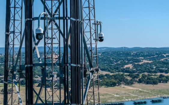
13 Pano AI cameras will be placed in Travis, Hays, Williamson and several other Central Texas counties.
AUSTIN, Texas — As Texas temperatures continue to soar, so does the risk of wildfires.
Austin was recently ranked the fifth-highest U.S. metro at risk for wildfire damage, according to a group called CoreLogic.
To help prevent such damage, Austin Energy has officially deployed an artificial intelligence (AI) system to better detect wildfires.
The system, called Pano AI, will monitor 437 square miles of Austin, the majority of Travis County, as well as some of Hays, Williamson, Bastrop and Burnet counties.
Thirteen cameras will use a combination of 360-degree technology and AI to detect smoke and determine where a fire is happening. It will then send that information to first responders in real-time.
“This is an important step for the safety of our community and the reliability of our electric system,” Austin Energy wildfire program manager Chris Vetromile said. “With climate change driving hotter, drier summers, this AI-powered detection system allows us to respond faster and more effectively to wildfires, safeguarding our community and supporting more reliable service.”
The implementation of this new technology was made possible by Austin Energy, the Austin Fire Department and the Texas Public Power Corridor Committee.
What is Pano AI?
Used in 15 areas across 20 million acres in the United States, Australia and British Columbia, Canada, Pano AI works to detect, find and share information about wildfires with professionals.
The device uses “ultra-high-definition cameras, geo satellite data, field sensors, legacy cameras, emergency alerts, and other data feeds” to spot fires within 15 miles and send details to first responders.