- They couldn’t save their daughters’ lives in the July 4 floods. Now they’re dealing with the grief and the guilt.
- Austin could see heavy rains, possible flooding over the next few days
- Families of campers, counselors who died in Texas Hill County floods sue Camp Mystic
- Small plane bound for Jamaica with hurricane relief supplies crashes in Florida neighborhood
- Ask the Meteorologist: Did a tornado hit Johnston County Saturday night?
Forecast: Rain chances ramp up Labor Day; minor flooding possible
Here are the latest updates from the KVUE Weather Team.
Shane Hinton (KVUE), Jordan Darensbourg, Hunter Williams, Grace Thornton
11:46 AM CST March 6, 2019
2:55 PM CDT September 1, 2024
AUSTIN, Texas — Sunday has been generally quiet for many, but rain in the Hill Country has been on and off for most of the day. This will be the story for the remainder of the evening until drier conditions take over after about 10 p.m.
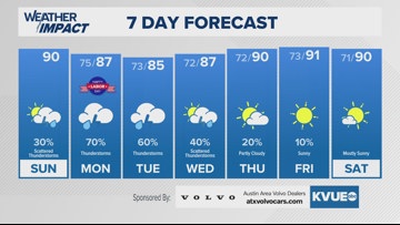
For Labor Day you will want to check the radar regularly if you are going to spend the day outside, this will moreso be for neighborhoods west of I-35, who have a level 2 “slight” risk for flooding Monday. Shower and storm chances will favor the Hill Country throughout the afternoon and evening, but we cannot rule out isolated heavy downpours for the Austin metro either.
Labor Day’s forecast will be repeated for the most part on Tuesday too, but the rain chance lowers to about 50%. Still, the rain pattern will favor Hill Country counties.
Due to thick clouds and rain for the start of the week, high temperatures will dip into the 80s area-wide.
We’re back to the lower 90s by Thursday, with sunnier skies ahead for next weekend.
As for the long-term period, the 6-10 day outlook is hinting at below-average temperatures next week, overnight readings could dip into the 60s!
SUNDAY:
Mostly cloudy. 20% chance for passing showers. Northeast wind at 5 to 10 mph.
HIGH: 90
SUNDAY NIGHT:
40% chance of showers or storm until 8 p.m. Northeast wind at 5 to 10 mph.
LOW: 76
SEVEN-DAY FORECAST:

Check out the live radar for what you can expect the rest of the day and into the workweek.