- They couldn’t save their daughters’ lives in the July 4 floods. Now they’re dealing with the grief and the guilt.
- Austin could see heavy rains, possible flooding over the next few days
- Families of campers, counselors who died in Texas Hill County floods sue Camp Mystic
- Small plane bound for Jamaica with hurricane relief supplies crashes in Florida neighborhood
- Ask the Meteorologist: Did a tornado hit Johnston County Saturday night?
Weather Impact Alert: dangerous travel conditions, flooding possible in the mountains Tuesday and Wednesday
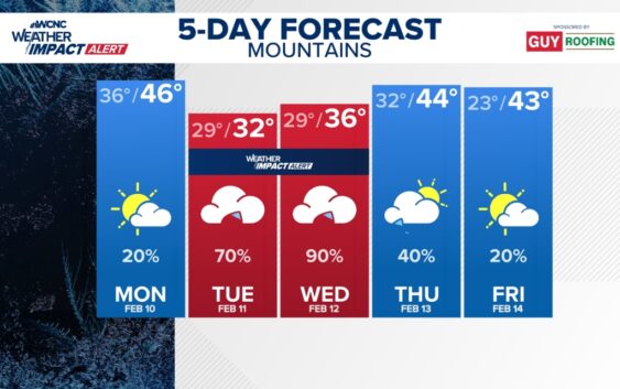
We are encouraging folks in the mountains to stay weather aware Tuesday and Wednesday due to the impacts from wintry precipitation.
CHARLOTTE, N.C. — A damp and dreary pattern sets up this week across the Carolinas, beginning early Tuesday morning.
The Charlotte area will experience off-and-on cold rain Tuesday through Wednesday. The heaviest of this rainfall will begin Tuesday around 10 p.m. and last until midday Wednesday. This means the biggest impact on the Charlotte area is the nuisance of this rain, which will be heavy at times, and isolated flooding.
However, for the mountains, the impacts will be more significant. Heavy rain will certainly lead to flooding risks, but these communities will mix in snow, sleet, and freezing rain too. This will be especially Tuesday morning through Tuesday evening, before the changeover to cold rain.
This will create dangerous travel conditions for the mountains, while ice accumulations up to 0.25″ could lead to isolated power outages and downed trees. This is why our team has issued a Weather Impact Alert for Ashe, Watauga, and Avery counties on Tuesday and Wednesday, and we’re encouraging folks to stay weather aware.
Rainfall accumulations could quickly add up to 3-5 inches across the mountains, with 2-3 inches across the Charlotte metro. Although the most impactful days are Tuesday and Wednesday, scattered rain will linger into Thursday.