- They couldn’t save their daughters’ lives in the July 4 floods. Now they’re dealing with the grief and the guilt.
- Austin could see heavy rains, possible flooding over the next few days
- Families of campers, counselors who died in Texas Hill County floods sue Camp Mystic
- Small plane bound for Jamaica with hurricane relief supplies crashes in Florida neighborhood
- Ask the Meteorologist: Did a tornado hit Johnston County Saturday night?
Forecast: Tornado Watch issued ahead of evening storms Memorial Day
Here are the latest updates from the KVUE Weather Impact Team.
Jordan Darensbourg, Hunter Williams, Grace Thornton
11:46 AM CST March 6, 2019
2:55 PM CDT May 26, 2025
AUSTIN, Texas — *A Tornado Watch has been issued for Mason, Llano, Gillespie, Burnet, Blanco, Hays, and Travis County until 10 p.m. Monday evening*
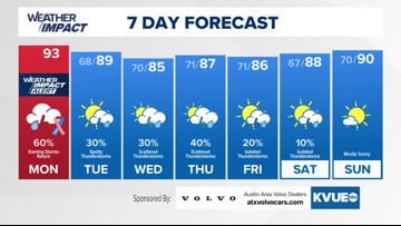
After a hot but quiet start to the long weekend, the weather pattern will become much more active for Memorial Day.
The KVUE Weather Team has issued a Weather Impact Alert Day for Monday, as Central Texas will have multiple chances for strong to severe thunderstorms. The first round of storms has already made it way through, but daytime heating this afternoon will prep the atmosphere for another round of late afternoon/evening storms that are expected to be quite strong on arrival.
All parts of Central Texas will have a good chance of seeing storms from this second round. Nearly all of the KVUE viewing area is under a Level 2 or 3 out of 5 risk for severe weather. Area west of I-35 are under the level 3 “enhanced” with very large hail and strong damaging winds expected to be the main threats. A brief tornado or localized flooding can’t be ruled out either.
The second round of stormy weather should move east before midnight tonight, but our forecast calls for more strong-severe storm potential for Tuesday, Wednesday, and Thursday this week. The silver lining will be the break for high heat and hopefully a bit of relief from our drought situation.
Over the next 7 days certain neighborhoods here locally could rack up 2-3″ inches of rain. It should feel like a spring-like end to spring, as meteorological summer begins on Sunday, June 1.
Stay tuned to the KVUE Weather Team for updates. The extended forecast is below:
