- They couldn’t save their daughters’ lives in the July 4 floods. Now they’re dealing with the grief and the guilt.
- Austin could see heavy rains, possible flooding over the next few days
- Families of campers, counselors who died in Texas Hill County floods sue Camp Mystic
- Small plane bound for Jamaica with hurricane relief supplies crashes in Florida neighborhood
- Ask the Meteorologist: Did a tornado hit Johnston County Saturday night?
Weather Impact Alert: Gusty downpours, flash flood warning issued
Scattered thunderstorms may bring heavy downpours to Houston today, impacting commutes.
HOUSTON — After a steamy start to the day, scattered thunderstorms could bring quick downpours across the Houston area this afternoon and early evening. Heavy rain may impact your commute or evening plans.
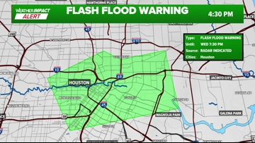
A Flash Flood Warning was issued for western Harris County—including downtown Houston, Montrose, and the Museum District—through 7:30 p.m. Thunderstorms have already dropped 1 to 3 inches of rain, with up to 2 more inches possible. Flash flooding is ongoing or expected to begin shortly.

The National Weather Service has issued a Flood Advisory for central Harris County which includes the city of Houston until 5:45 p.m. At 3:41 p.m., radar indicates heavy rain due to thunderstorms. Minor flooding is ongoing or expected to begin short in area circled in green. This includes I-610, I-10, I-45, I-69 through central Houston. Exercise extreme caution on roadways.
1-2″ of rain has fallen and additional rain is expected within the next few hours.
A ground delay was in effect for flights out of George Bush Intercontinental Airport because of storms.
Weather Impact Alert
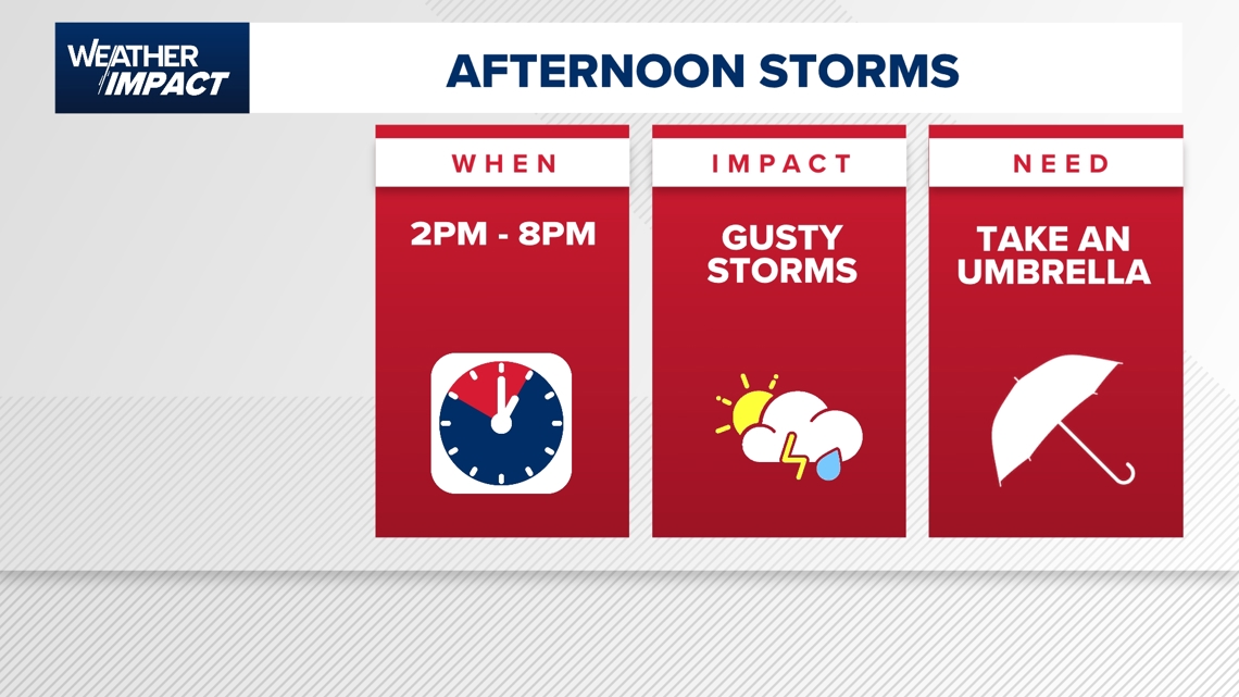
The KHOU 11 Weather Team has issued an hourly Weather Impact Alert for this afternoon as storm chances return. The greatest window for gusty downpours and pop-up storms is between 2 p.m. and 8 p.m., especially across the Houston metro. While not everyone will see rain, storms that do develop could come with brief heavy rain and wind gusts, so plan ahead if you’ll be on the roads or outdoors.
- Keep that umbrella handy, especially if you’ll be outside during the evening commute.
- Storms may form in clusters and impact different areas at different times.

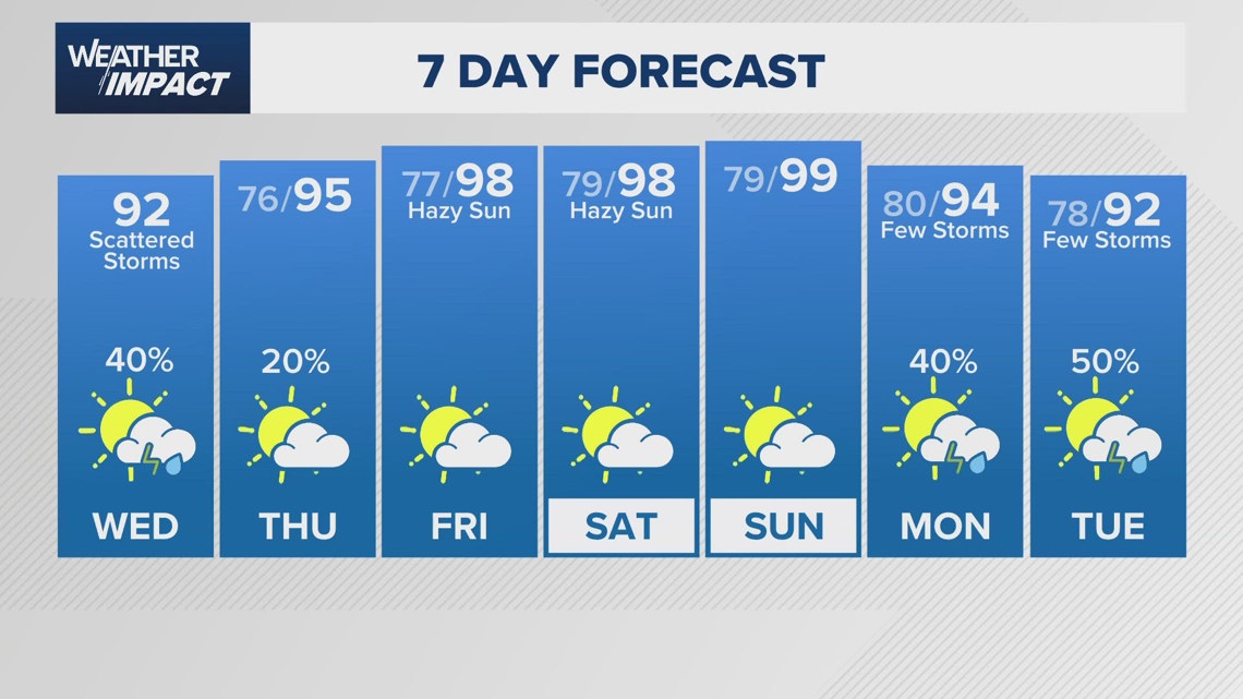
Rain returns, but no severe threat expected today
What to expect:
- Spotty thunderstorms, heavy downpours, and isolated pockets of rain.
- Quick bursts of rainfall totals between 0.25″ and 0.5″, possibly higher in isolated areas.
- No hail or tornado threat at this time.
Timing: When storms are most likely
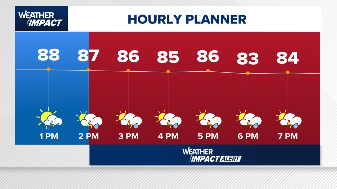
2 PM to 8 PM: Peak storm window with the most widespread downpours expected.
After Sunset: Storms taper off as daytime heating fades.
“Once we get to about 2 or 3 o’clock, that’s when thunderstorms start to become a little bit more area-wide… a quick downpour like yesterday will be possible throughout your afternoon and into your early evening.” KHOU 11 Meteorologist Chita Craft said.

Who’s most at risk?
Regions currently seeing showers: Bryan, College Station, Navasota, Summerville.
Houston Metro Area: Afternoon downpours are expected but scattered.
Areas to Watch: Communities north and northwest of Houston may see activity earlier.
What you should do
Bring your umbrella and consider alternate plans for the afternoon.
Expect delays if driving during peak storm hours — sudden heavy rainfall could reduce visibility.

Looking ahead: Hazy weekend, rising temps
Thursday: Lower rain chance (around 20%), fewer storms.
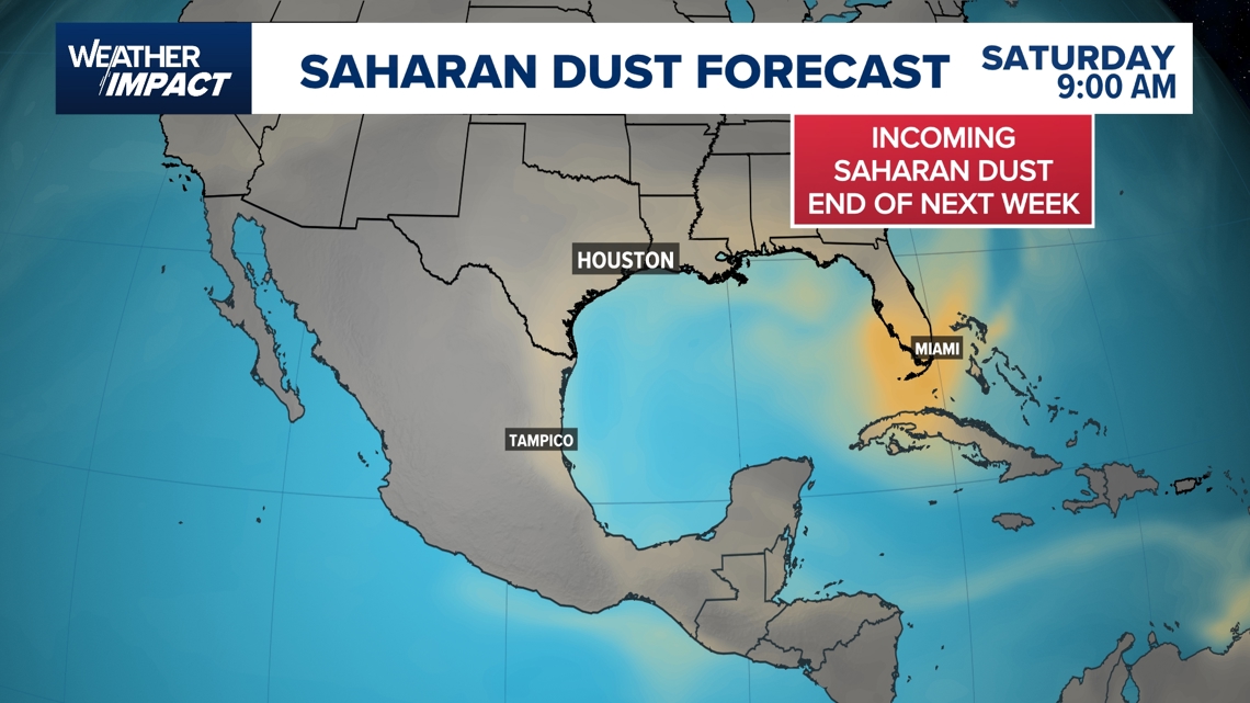
Friday–Saturday: Saharan dust moves in — expect hazy skies and potential air quality impacts.
Sunday: First triple-digit heat? Temperatures could hit 100°F or more.
“Some of those downpours this afternoon — and then we’re pushing back to 100 Sunday afternoon. It gets really hot for the upcoming weekend,” KHOU 11 Meteorologist Chita Craft said.