- They couldn’t save their daughters’ lives in the July 4 floods. Now they’re dealing with the grief and the guilt.
- Austin could see heavy rains, possible flooding over the next few days
- Families of campers, counselors who died in Texas Hill County floods sue Camp Mystic
- Small plane bound for Jamaica with hurricane relief supplies crashes in Florida neighborhood
- Ask the Meteorologist: Did a tornado hit Johnston County Saturday night?
Houston forecast: Rain showers, flash flood warning through 7:30 p.m.
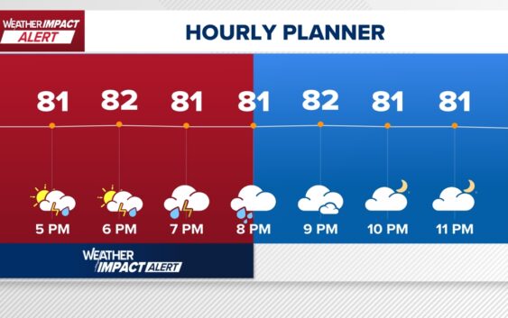
HOUSTON — After a steamy start to the day, scattered thunderstorms brought quick downpours across the Houston area this afternoon and early evening. Rain may impact your commute or evening plans.
A Flash Flood Warning was issued for western Harris County—including downtown Houston, Montrose, and the Museum District—through 7:30 p.m. Thunderstorms have already dropped 1 to 3 inches of rain, with up to 2 more inches possible. Flash flooding is ongoing or expected to begin shortly.
A ground delay was in effect for flights out of George Bush Intercontinental Airport because of storms.
The KHOU 11 Weather Team issued a Weather Impact Alert for this afternoon storm chances. The alert ended at 5:45 p.m.
Thursday: Lower rain chance (around 20%), fewer storms.
Friday–Saturday: Saharan dust moves in — expect hazy skies and potential air quality impacts.
Sunday: First triple-digit heat? Temperatures could hit 100°F or more.
“Some of those downpours this afternoon — and then we’re pushing back to 100 Sunday afternoon. It gets really hot for the upcoming weekend,” KHOU 11 Meteorologist Chita Craft said.
Harris County (including Houston, Pasadena, Baytown), Fort Bend County (Richmond, Sugar Land, Missouri City), Montgomery County (Conroe, The Woodlands), Brazoria County (Angleton, Pearland, Alvin, Lake Jackson), Galveston County (Galveston, League City, Texas City), Liberty County (Liberty, Cleveland, Dayton), Walker County (Huntsville, New Waverly), Waller County (Hempstead, Prairie View, Waller), Polk County (Livingston, Corrigan), Chambers County (Anahuac, Mont Belvieu, Winnie), Wharton County (Wharton, El Campo), Washington County (Brenham), Matagorda County (Bay City, Palacios), Grimes County (Anderson, Navasota), Austin County (Bellville, Sealy), Colorado County (Columbus, Eagle Lake, Weimar), Trinity County (Groveton, Trinity).