- They couldn’t save their daughters’ lives in the July 4 floods. Now they’re dealing with the grief and the guilt.
- Austin could see heavy rains, possible flooding over the next few days
- Families of campers, counselors who died in Texas Hill County floods sue Camp Mystic
- Small plane bound for Jamaica with hurricane relief supplies crashes in Florida neighborhood
- Ask the Meteorologist: Did a tornado hit Johnston County Saturday night?
Forecast: Flood Watch issued as more rain approaches Wednesday night
Here are the latest updates from the KVUE Weather Impact Team.
Jordan Darensbourg, Hunter Williams, Grace Thornton, KC Sherman
11:46 AM CST March 6, 2019
2:16 PM CDT June 11, 2025
AUSTIN, Texas — *A Flood Watch has been issued from 7 p.m. Wednesday to 7 p.m. Thursday for Burnet, Williamson, Travis, Milam, Lee, Bastrop, and Fayette County*
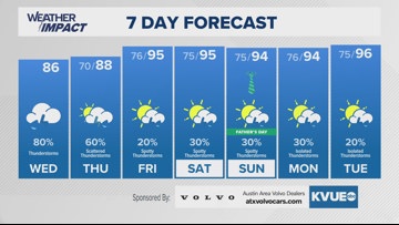
We’ve tracking a very wet and soggy pattern for these next couple of days, and an increased flood potential is forecast for this period as a result.
Thunderstorms containing heavy rain are likely through the early evening into the overnight hours again for Wednesday, and many low water crossings will need to be watched very closely for any flash flooding. If there are any flooded roads, for the love of all things holy please do not drive into them. Turn around and find another way.
This pattern continues until the end of the week with spotty rounds of storms for Friday and Saturday and maybe even into Father’s Day as well.
Temperature-wise, we’re tracking 80s for highs Wednesday and Thursday, with Friday onward returning to the 90s.
Find the full extended forecast below:
