- Why no hurricanes made landfall in the US in 2025
- Florence to begin interviewing police chief finalists in January
- A West Texas county wants to better prepare for floods. Paying for it will be tricky.
- They couldn’t save their daughters’ lives in the July 4 floods. Now they’re dealing with the grief and the guilt.
- Austin could see heavy rains, possible flooding over the next few days
San Antonio hit with deluge of rainfall amid tornado, flood warnings
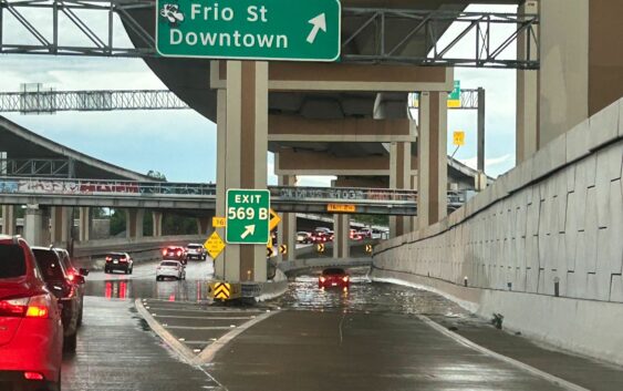
Severe storms struck overnight in San Antonio and across South Central Texas, dropping a deluge of precipitation causing flash floods that left at least two dead.
Continued weather warnings remain in effect, including a flash flood warning until 1:45 p.m. and a flood watch through 7 p.m.
According to the National Weather Service, there was 5.87 inches of precipitation observed at the San Antonio International Airport at 6:51 a.m. on Thursday, June 12, up from 0.25 of an inch that recorded at 12:51 a.m.
The San Antonio River at Loop 410 was at 3.85 feet at 4:15 a.m. before spiking at 25.10 feet and hitting the moderate flood stage at 7 a.m., according to the National Water Prediction Service. The river would in the major flood stage once it hits 26 feet.
At 8:15 a.m., the flood stage had dropped to 20.33 feet. The flood stage will drop to minor once it drops under 20 feet.
The San Antonio River at Elemendorf was at 10.53 feet at 8:30 a.m.. The NWPS is forecasting the flood stage to continue rising to the minor flood stage at approximately 37.30 feet into the overnight hours into early Friday, June 13.
The San Antonio River at Mitchell Street peaked in the minor flood stage at 14.39 feet at 5:05 a.m. and has been decreasing in the hours since, according to the NWPS.
Salado Creek at Loop 13 is on the rise, as it began rising from 5.3 feet at 4 a.m. up to 10.75 feet by 8:15 a.m. NWPS is forecasting the creek to peak at approximately 16.50 feet and not quite hitting the minor flood stage, which is set at 18 feet. The gauge for Salado Creek at northeast Loop 410 is out of service due to construction.
Leon Creek is forecast to see some high water levels. At I-35, the creek saw the levels rise from just over two feet at 12:30 a.m. to 7.87 feet at 8:15 a.m. The area is forecast to hit 14 feet which is just under the minor flood stage at 15 feet.
Leon Creek at Loop 410 near Leon Valley spike at 18.6 feet at 4:15 a.m. and dropped back down to 13.03 feet by 8:15 a.m.
Most trails at the Guadalupe River State Park are temporarily closed because of the recent rains.
Some trails — the Bald Cypress Trail, River Overlook Trail, Discovery Center Loop and Bauer Unit — are open to foot traffic only, according to a June, 11, 2025, Facebook post by the state park.
The post said the soggy trails “lose the ability to support traffic, which can lead to erosion, trail damage and harm to surrounding ecosystems.”
Because of the recent heavy rain and with more in the forecast, officials are also urging visitors to stay out of the Guadalupe River until conditions improve. According to the post, the river’s flow can increase suddenly and without warning, creating a potentially dangerous situation.