- Eric Tulsky comfortable, confident and going for the Stanley Cup in 2nd year as Hurricanes GM
- 5 homes collapse into the surf of the Outer Banks as hurricanes rumble in Atlantic
- As hurricanes pass offshore, more Buxton homes collapse into the sea
- Central Texas floods reveal need to shore up disaster response in unincorporated areas
- Latest: Tropical Storm Imelda will pull away from East Coast, expected to become a hurricane
Houston forecast: Heavy rain and strong storms trigger flood warnings in the Houston area
Flooding threatens Brazoria, Matagorda and Wharton counties amid heavy rain.
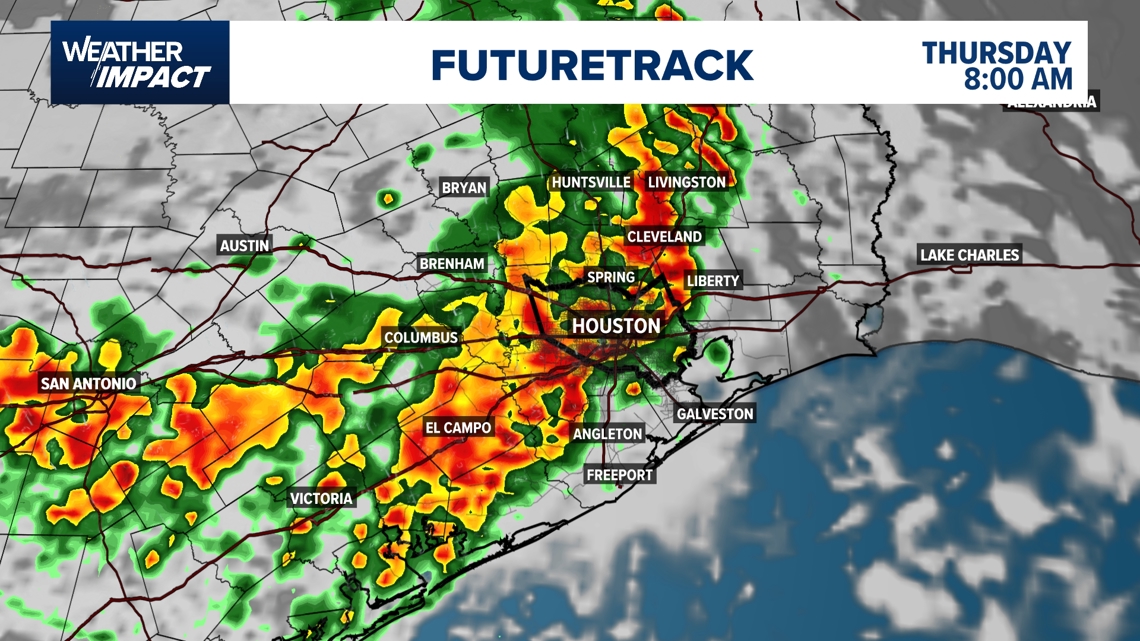
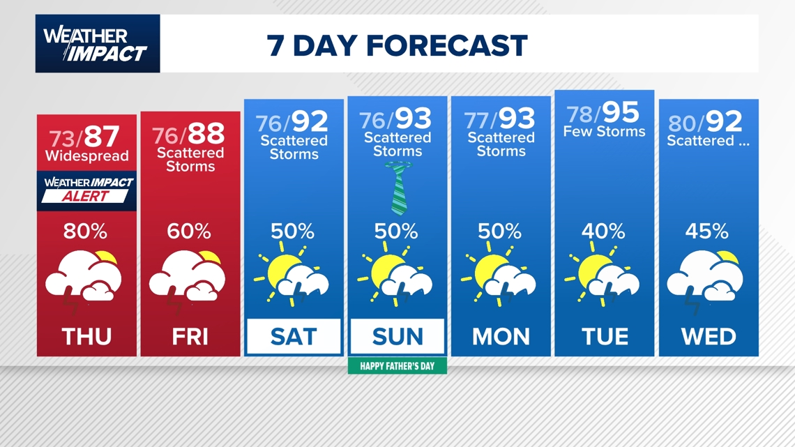
HOUSTON — Thursday will bring another day with widespread showers and thunderstorms. Rain chances ramp up quickly through the early morning hours and continue through noon. We could see lingering showers through the afternoon.
Current watches and warnings:
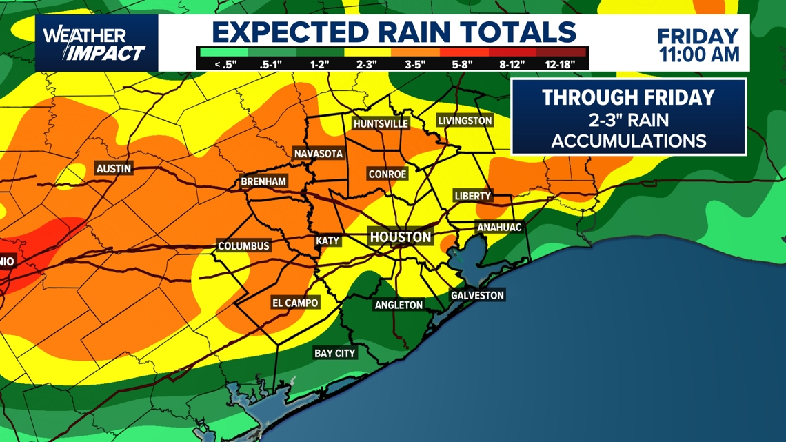
- A Flood Warning is in effect until 3:30 p.m. for parts of south-central and southeast Texas, including Jackson, Brazoria, Matagorda, and Wharton counties. Between 3 and 10 inches of rain have already fallen, and flooding is ongoing or expected to begin shortly in areas such as Lake Jackson, Bay City, Freeport, and Edna. An additional 0.5 to 1 inch of rain is possible, and it will take several hours for water to drain from urban and low-lying areas.
- A Flood Watch is in effect through Thursday evening for the Houston metro and surrounding coastal and inland areas, including Galveston, Fort Bend, Wharton, and Jackson counties.
Weather Impact Alert canceled
The KHOU 11 Weather Team ended Weather Impact Alert at 2 p.m. Thursday.
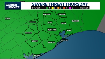
Severe storm risk: Gusty winds, heavy rain, ponding on roadways
A Level 1 out of 5 (Marginal Risk) has been issued for much of Southeast Texas, including Houston, Sugar Land, Tomball, Conroe, Liberty, and El Campo. This means there’s an elevated risk for damaging wind gusts, heavy rain, and dangerous lightning.
Threats include:
- Damaging wind gusts
- Heavy downpours leading to street flooding

Flooding risk expands across Southeast Texas
A moderate flood risk (Level 3 of 4) is in place for much of Southeast Texas today, including Houston, Galveston, Sugar Land, Conroe, Bay City, and Victoria. This means multiple rounds of rain could lead to widespread street flooding, especially in low-lying or poorly draining areas.
- Areas like El Campo, Angleton, Liberty, and Columbus are also firmly in the red zone.
- Brenham, Huntsville, and Livingston are near the northern edge of the risk area, while Austin and parts of East Texas are in the lower “slight” or “marginal” categories.
If you’re in the red zone, plan your travel carefully and expect water over roads in flood-prone spots.

Timing the storms
The storms will move in early Thursday morning and linger through midday:
- By 1 p.m. – Storms push toward the coast and into far eastern counties
- After 3 p.m. – Conditions begin to settle down
Storms may arrive in one main round, but lingering showers are possible throughout the day.

Areas most at risk
- Entire Houston metro is under a Level 2 risk for severe storms.
- Northwest of Houston (e.g., Wharton, Columbus, north of Katy): May see the first signs of morning activity.
- South and coastal areas (e.g., Galveston, Pearland): Could see evening storms as activity shifts southward.

What you should do
- Delay your commute or morning errands if possible. Roads may be waterlogged and dangerous by sunrise.
- Drive slowly and avoid flooded streets.
- Charge your devices Wednesday night in case of power outages due to high winds.
- Monitor alerts: Watches or warnings may be issued overnight or early Thursday.
Looking ahead: More rain, then heat
- Friday: 60% chance of more rain and street flooding
- Weekend: 50/50 shot at scattered thunderstorms for both Saturday and Father’s Day
- Next week: Daily chances for pop-up showers and storms continue

Counties we serve:
Harris County (including Houston, Pasadena, Baytown), Fort Bend County (Richmond, Sugar Land, Missouri City), Montgomery County (Conroe, The Woodlands), Brazoria County (Angleton, Pearland, Alvin, Lake Jackson), Galveston County (Galveston, League City, Texas City), Liberty County (Liberty, Cleveland, Dayton), Walker County (Huntsville, New Waverly), Waller County (Hempstead, Prairie View, Waller), Polk County (Livingston, Corrigan), Chambers County (Anahuac, Mont Belvieu, Winnie), Wharton County (Wharton, El Campo), Washington County (Brenham), Matagorda County (Bay City, Palacios), Grimes County (Anderson, Navasota), Austin County (Bellville, Sealy), Colorado County (Columbus, Eagle Lake, Weimar), Trinity County (Groveton, Trinity).