- Eric Tulsky comfortable, confident and going for the Stanley Cup in 2nd year as Hurricanes GM
- 5 homes collapse into the surf of the Outer Banks as hurricanes rumble in Atlantic
- As hurricanes pass offshore, more Buxton homes collapse into the sea
- Central Texas floods reveal need to shore up disaster response in unincorporated areas
- Latest: Tropical Storm Imelda will pull away from East Coast, expected to become a hurricane
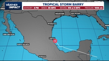
Tropical Storm Barry Strengthens As It Heads Toward Landfall Tonight
Barry is the second named storm of the Atlantic Hurricane Season. It’s expected to move into Mexico, but will send rain up to Texas.
HOUSTON — What was Tropical Depression 2 in the southern Gulf is now Tropical Storm Barry, according to the National Hurricane Center. While Barry is expected to move into Mexico, it should bring plenty of rain to Texas, including in the Houston area.
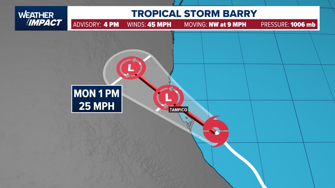
With the 4 p.m. Sunday update, Barry had maximum sustained winds at 45 miles per hour and was moving to the northwest at 9 miles per hour. Computer modeling suggests Barry will move inland near Tampico, Mexico, at some point Monday.
Current situation
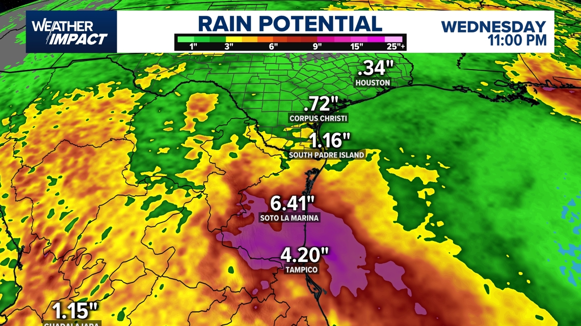
The system should stay well south of the Houston area, thanks to a high-pressure system building over Texas and wind shear over the Gulf north of the system. While models have the system heading west into Mexico, we do think it’ll sling moisture up along the Texas coast, increasing our rain chances. We’ve had widespread tropical downpours Sunday. Expect a few more scattered showers and thunderstorms on Monday as remnant moisture remains.


Potential impacts
Although the systems center is hundreds of miles from Houston, it will have the potential to bring deep tropical moisture and heavy downpours into southeast Texas on Sunday.
“Even if this does just stay here, you know, it’s a broad counterclockwise rotation and that would sling moisture even up into the Texas coast,” David explained. “It could sling moisture up here even if nothing develops at all we could have an enhanced rain chances.”

Something New To Watch:
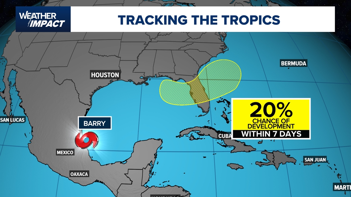
An now, another spot for us to keep track of this week. The Hurricane Center is watching an area of disturbed weather near Florida that will have a slight (20%) chance for development over the next 7 days. It’s something we’ll be watching closely with updates several times a day, here, and on KHOU11+. Download the app on your TV for extended video updates.

Storm naming
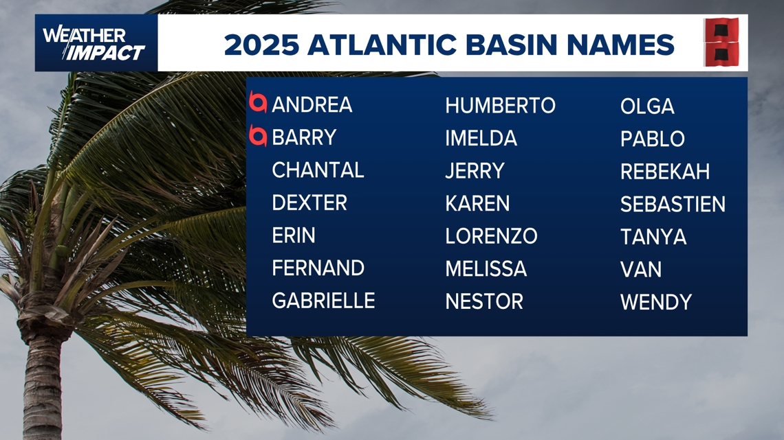
If the disturbance develops into a tropical storm, it would be named Barry. The 2025 Atlantic hurricane season has already produced one named storm – Andrea, which formed north of Bermuda and moved into the open Atlantic without affecting land.
Statistically, June and July development typically occurs in the Gulf, Western Caribbean, or along the east coast.

Stay informed
Residents along the Gulf Coast should continue monitoring tropical updates as the situation develops this weekend. The KHOU 11 weather team will provide continued coverage of any tropical development.
How to watch KHOU 11+
Downloading the KHOU 11+ app to your Roku, Amazon FireTV or Apple TV streaming device is simple and easy.
- Go to the app store on your Roku, Amazon FireTV or Apple TV device.
- Search for “KHOU 11+”
- Select the KHOU 11+ app
- Download the app to your device for free
- Start watching KHOU 11 around the clock!
When you open the KHOU 11+ app, you’ll first see an option to view our 24/7 stream, which will air all KHOU 11 newscasts and breaking coverage, along with newscast replays, in case you missed a show.
Trying to catch up on the news of the day or learn more about the happenings across southeast Texas? The KHOU 11+ app has you covered — 24 hours a day, seven days a week.