- They couldn’t save their daughters’ lives in the July 4 floods. Now they’re dealing with the grief and the guilt.
- Austin could see heavy rains, possible flooding over the next few days
- Families of campers, counselors who died in Texas Hill County floods sue Camp Mystic
- Small plane bound for Jamaica with hurricane relief supplies crashes in Florida neighborhood
- Ask the Meteorologist: Did a tornado hit Johnston County Saturday night?
Forecast: Flood Watch expires, but additional storms will be possible through midweek
Here are the latest updates from the KVUE Weather Impact Team.
Jordan Darensbourg, Hunter Williams, Grace Thornton, KC Sherman
11:46 AM CST March 6, 2019
5:10 AM CDT July 8, 2025
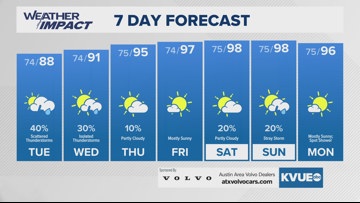
AUSTIN, Texas — For the first time since Thursday evening, there are no active flood watches or warnings across the area as we head into the start of Tuesday. The flood threat will finally lower Tuesday, though rounds of showers and storms will still be possible for the afternoon. The highest storm chances Tuesday, however, will be away from the hardest hit areas, with the main focus along and east of I-35 into the Coastal Plains. Some areas in those locations could still pick up an additional 2″ – 3″ of rain where heavy downpours set up.
Wednesday will bring additional rounds of spotty rain and storms as a disturbance moves in from the Gulf, Wednesday’s rain chances will spread back into the Hill Country a little, but the higher chances will likely remain along and east of I-35.
By Thursday and Friday, drier and hotter conditions. With lots of sunshine and highs back into the middle 90s, this will give our area a good chance to dry out.
The weekend will bring the return of some rain chances, but right now those chances are only at a 20% probability.
The KVUE weather team will continue to keep you updated on any changes. Here’s the full seven-day forecast below:
