- Eric Tulsky comfortable, confident and going for the Stanley Cup in 2nd year as Hurricanes GM
- 5 homes collapse into the surf of the Outer Banks as hurricanes rumble in Atlantic
- As hurricanes pass offshore, more Buxton homes collapse into the sea
- Central Texas floods reveal need to shore up disaster response in unincorporated areas
- Latest: Tropical Storm Imelda will pull away from East Coast, expected to become a hurricane
Forecast: Minor flooding risk through midweek; drier eventually
Here are the latest updates from the KVUE Weather Impact Team.
Jordan Darensbourg, Hunter Williams, Grace Thornton, KC Sherman
11:46 AM CST March 6, 2019
1:40 PM CDT July 8, 2025
AUSTIN, Texas — For the first time since Thursday evening, there are no active flood watches or warnings across the area as we start Tuesday.
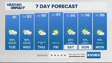
The flood threat will finally lower Tuesday, though rounds of showers and storms will still be possible in the afternoon. The highest storm chances Tuesday will be away from the hardest hit areas, with the main focus along and east of Interstate 35 into the Coastal Plains. Some areas in those locations could still pick up an additional 2 to 3 inches of rain where heavy downpours set up.
Wednesday will bring additional rounds of spotty rain and storms as a disturbance moves in from the Gulf. Wednesday’s rain chances will spread back into the Hill Country slightly, but the higher chances will likely remain along and east of I-35.
By Thursday and Friday, drier and hotter conditions are expected. With lots of sunshine and highs back into the mid-90s, this will give our area a good chance to dry out.
The weekend will bring the return of some rain chances, but right now, those chances are only at a 20% probability.
The KVUE weather team will continue to keep you updated on any changes. Here’s the full seven-day forecast below:
