- They couldn’t save their daughters’ lives in the July 4 floods. Now they’re dealing with the grief and the guilt.
- Austin could see heavy rains, possible flooding over the next few days
- Families of campers, counselors who died in Texas Hill County floods sue Camp Mystic
- Small plane bound for Jamaica with hurricane relief supplies crashes in Florida neighborhood
- Ask the Meteorologist: Did a tornado hit Johnston County Saturday night?
Severe weather threatens Central Texas
The combination of unseasonably warm air, abundant moisture, and an incoming upper-level storm system will set the stage for possible severe weather Wednesday night.
The line of thunderstorms will enter the Hill Country tonight between 9 p.m. and 11 p.m. and near the I-35 corridor by midnight.
Rainfall should come to an end for Fayette, Lee, and Milam Counties by sunrise.
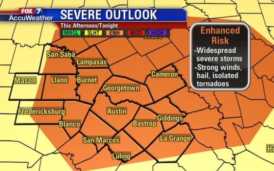
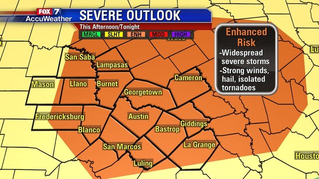
As of Wednesday morning, the National Weather Service’s Storm Prediction Center had an “Enhanced Risk” of severe weather in place for much of Central Texas.
An “Enhanced Risk” means widespread severe weather is possible with hazards like damaging thunderstorm wind gusts, large hail, and a few tornadoes.
Severe weather is a relatively uncommon occurrence for December in this area.
The last time Central Texas saw an “Enhanced Risk” for severe weather during the month of December was December 26, 2016.
The last Severe Thunderstorm Watch issued for Austin in December was in 2012.
Severe weather is much more hazardous at night. Those in the path of these storms should have a reliable way to receive weather alerts overnight.