- 911 calls from Texas floods reveal chaotic and desperate pleas for rescues
- Carolina Beach is warning of potential King Tide flooding
- NCDEQ launches Hurricane Helene recovery grants program
- Why no hurricanes made landfall in the US in 2025
- Florence to begin interviewing police chief finalists in January
Storm could bring damaging winds and hail to the Charlotte area Monday afternoon
CHARLOTTE, N.C. — Monday comes with the chance for storms in the afternoon and evening. Most of the Charlotte area is currently under a moderate risk for severe storms. This means that we could have some damaging winds and large hail as their primary threats.
Charlotte is right in the middle of this, meaning you need to be weather aware later on Monday, especially during the evening commute.
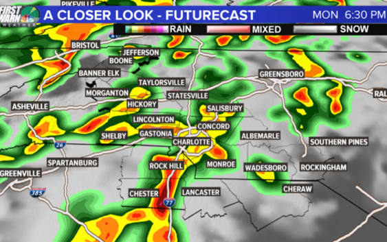
Below is a look at an example of what our radar may look like late afternoon and early evening. We have a possible multicell environment across the area. Meaning, scattered strong to severe thunderstorms from the mountains down to the sandhills.

WCNC
Even if these storms avoid severe criteria, they will produce some very heavy rain up to 1-2 inches through Monday.
Luckily, we have been dry so this will limit minor flooding, but some areas could still see this briefly.
Storms are possible through the evening and overnight Monday, dying out Tuesday morning.
Rain will have its final surge on Tuesday afternoon with a few thunderstorms but it should be tamer than Monday. Everything is dry and sunny come Wednesday!