- Demolition begins on flood-damaged homes in Stoney Creek as neighbors await relief
- NC Office of State Fire Marshal aiding in Hurricane Melissa relief efforts
- U.S.-based aid groups rush to get supplies into storm-battered Jamaica after Hurricane Melissa
- Travelers stuck in Jamaica due to Hurricane Mellissa forced to pay for unwanted extended stay
- Raleigh police officer awaits word from family in Jamaica after Hurricane Melissa devastation
Maze: Storms possible tonight, but not a repeat of Monday's severe weather
Raleigh, N.C. — Storms will be possible again in central North Carolina on Tuesday evening, but it will not be a repeat of last night, according to WRAL meteorologist Mike Maze.
While there’s an elevated risk for severe weather in some areas south of the Triangle on Tuesday, serious storms are less likely than they were Monday evening.
The system could roll into the area between 4 and 6 p.m. and should clear out around 9 p.m., Maze said.
While some storms are possible in the Triangle, southern counties will be the most affected. There is a small risk there for hail, damaging winds or isolated tornadoes.
“If we do see anything it would be wind damage and small hail, but that is looking less and less likely,” he said.
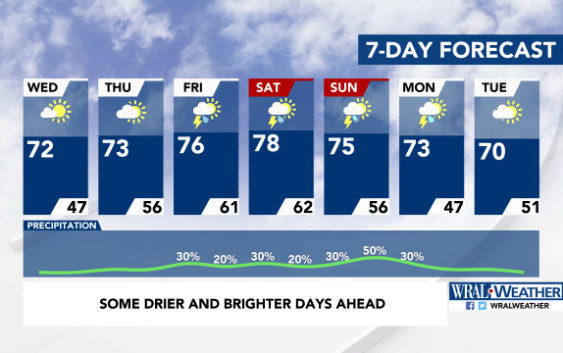
Wednesday will be much clearer with sunshine and a high around 72 degrees.
The rest of the week will stay warm, with highs in the 70s expected each day. Another chance for rain moves in Friday, although the timing is unclear.
The Triangle got about 2 inches of rain Monday night as a storm system moved through central North Carolina, hitting Johnston, Wilson and Edgecombe counties the hardest.