- They couldn’t save their daughters’ lives in the July 4 floods. Now they’re dealing with the grief and the guilt.
- Austin could see heavy rains, possible flooding over the next few days
- Families of campers, counselors who died in Texas Hill County floods sue Camp Mystic
- Small plane bound for Jamaica with hurricane relief supplies crashes in Florida neighborhood
- Ask the Meteorologist: Did a tornado hit Johnston County Saturday night?
Severe Storms With Large Hail And High Winds Are Possible This Evening Into Early Thursday Morning
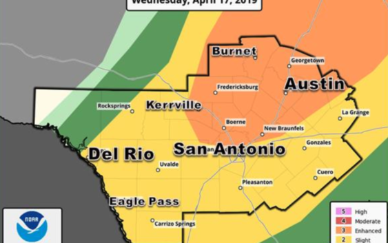
Large hail and damaging winds are the most likely threat facing Austin and much of South Central Texas this evening into Thursday morning, the National Weather Service says.
An isolated tornado is also possible with tonight’s storms, the NWS warns. The weather service puts the chance of precipitation for Austin at 90 percent tonight, with between one-half and three-quarters of an inch of rain possible.
During the day Wednesday, there’s a 30 percent chance of showers, especially after 1 p.m. when thunderstorms are possible.
The National Weather Service in Austin/San Antonio tweeted a forecast model showing the brunt of the storms hitting Austin around 1 a.m. — noting the actual time and intensity of the storm’s arrival may change.
Strong to severe thunderstorms are possible this evening through early Thursday morning, including parts of the Austin and San Antonio metros. Large hail and damaging winds are the main threats, but locally heavy rain and a tornado will also be possible. pic.twitter.com/6vNFc4dnHl
— NWS Austin/San Antonio (@NWSSanAntonio) April 17, 2019
RELATED | 8 Ways To Stay Ahead Of Severe Weather In Central Texas
Thursday is expected to be sunny with a high near 74 degrees.