- They couldn’t save their daughters’ lives in the July 4 floods. Now they’re dealing with the grief and the guilt.
- Austin could see heavy rains, possible flooding over the next few days
- Families of campers, counselors who died in Texas Hill County floods sue Camp Mystic
- Small plane bound for Jamaica with hurricane relief supplies crashes in Florida neighborhood
- Ask the Meteorologist: Did a tornado hit Johnston County Saturday night?
Raleigh area, parts of Sandhills at low risk for severe weather Saturday
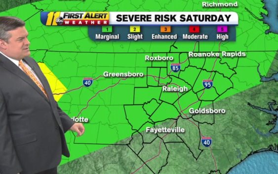
RALEIGH (WTVD) — ABC11 is in First Alert Mode as most of central and northern North Carolina are at risk for severe weather on Saturday.
Don “Big Weather” Schwenneker said while our area is under a marginal risk, the areas west of us should get the brunt of the storm.
Don “Big Weather” Schwenneker said while our area is under a marginal risk, the areas west of us should get the brunt of the storm.
The @NWSSPC has the central & northern part of the viewing area under a Marginal (Category 1) risk for severe weather for Saturday. Biggest threat=damaging winds. #ncwx pic.twitter.com/42T8UkCjNG
— Don Schwenneker (@BigweatherABC11) May 3, 2019
He said we should be dry most of the day but a stray shower or thunderstorm could push in and turn severe.
The storm should blow into our area Saturday afternoon and evening.
RELATED: Tropical cyclone could develop near the Bahamas in the next 5 days, NHC says
He said the biggest threats are damaging winds and pockets of hail.
Copyright © 2019 WTVD-TV. All Rights Reserved.