- They couldn’t save their daughters’ lives in the July 4 floods. Now they’re dealing with the grief and the guilt.
- Austin could see heavy rains, possible flooding over the next few days
- Families of campers, counselors who died in Texas Hill County floods sue Camp Mystic
- Small plane bound for Jamaica with hurricane relief supplies crashes in Florida neighborhood
- Ask the Meteorologist: Did a tornado hit Johnston County Saturday night?
FORECAST: Potential for severe weather tonight
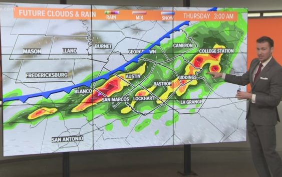
AUSTIN, Texas — Weather Outlook
A line of severe thunderstorms is forming out in west Texas this afternoon. The line will gradually make it’s way to the Austin metro but will lose some intensity as it does so. We’ll go for a 60% chance of showers and thunderstorms as the broken line makes it’s way to Central Texas, some storms could still be severe with large hail and damaging winds being the main threat. We begin to dry out and warm up beginning Saturday as high pressure begins to build over Texas.
DETAILED FORECAST:
TONIGHT:
Scattered showers and thunderstorms. A 60% chance of rain, a few storms could be strong with damaging winds and large hail. A strong southeast wind at 10 to 15 shifting to a northeast wind at 5 to 10 mph.
LOW: 72°
TOMORROW:
Mostly cloudy and cooler with a 40% chance of showers throughout the day. Northeast winds from 5 to 10 mph.
HIGH: 86°
FRIDAY:
Mostly cloudy with a 20% chance of a lingering shower in the morning. Winds shifting from the northeast to the east/southeast 5 to 10 mph.
HIGH: 86°
RELATED: Allergy Report
Stay with KVUE on social media and download the KVUE News app so you can stay ahead of the storm. kvue.com/app