- Disaster declaration issued by San Antonio-area leaders after historic floods that killed 13
- Officials issue disaster declaration after deadly June 12 flooding in San Antonio
- Florence Co. investigators travel to Brunswick County for human remains, missing person case
- North Carolina lawmakers clash over next round of Hurricane Helene funding
- City of San Antonio launching investigation into cause of last week's deadly flooding
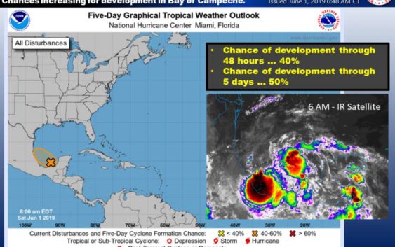
On the first day of hurricane season, Gulf disturbance expected to bring heavy rain to Houston
-
A tropical disturbance in the southern Gulf of Mexico could bring heavy rainfall to the Houston area on Wednesday and Thursday.
A tropical disturbance in the southern Gulf of Mexico could bring heavy rainfall to the Houston area on Wednesday and Thursday.
Photo: National Weather Service
A tropical disturbance in the southern Gulf of Mexico could bring heavy rainfall to the Houston area on Wednesday and Thursday.
A tropical disturbance in the southern Gulf of Mexico could bring heavy rainfall to the Houston area on Wednesday and Thursday.
Photo: National Weather Service
A tropical disturbance in the southern Gulf of Mexico might bring some wet weather to Southeast Texas next week.
The system is currently moving toward southern Mexico and could approach the Houston region by the middle of next week, according to the National Weather Service. If it does, expect widespread showers and thunderstorms on Wednesday and Thursday, with the coastal counties seeing heavy rainfall beginning Wednesday night.
Sea levels may also rise with the rain, with tides and rip currents on the increase as well.
Read More: Forecast of ‘near-normal’ hurricane season isn’t certain, experts say
Most of the National Weather Service models show the moisture plume heading east into Louisiana by Friday.
The Atlantic hurricane season begins today.
nick.powell@chron.com