- U.S.-based aid groups rush to get supplies into storm-battered Jamaica after Hurricane Melissa
- Travelers stuck in Jamaica due to Hurricane Mellissa forced to pay for unwanted extended stay
- Raleigh police officer awaits word from family in Jamaica after Hurricane Melissa devastation
- North Carolina’s leaders give insight on the effects of Hurricane Melissa
- ‘We want some answers;’ Whiteville residents demand city response to prevent flooding
Flash flood watch issued as severe weather possible in the Triangle
Raleigh, N.C. — Much of central North Carolina is under the threat of severe weather Tuesday as a cold front moves through the region, bringing the possibility of heavy downpours, gusty winds and lightning.
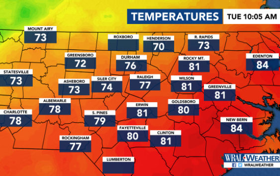
A flash flood watch was issued for numerous counties, including Durham, Johnston, Orange, Wake and Wilson, from 2 p.m. to 11 p.m.
Several areas are under a Level 2 risk for severe weather, including Fayetteville, Rocky Mount and Wilson, while Durham and Charlotte are under a Level 1 risk of severe weather, according to the storm prediction center.
Raleigh and Wake County are on the dividing line for the risk, so residents should expect stormy weather as well.
WRAL meteorologist Elizabeth Gardner said an approaching cold front moving eastward will trigger the storms and bring cooler weather in its wake after several days of sweltering heat and humidity blanketed the Triangle.
Tuesday’s high is expected to be 80 degrees.
Rain fell in the early hours of Tuesday but cleared before the morning commute. More rain will move in by lunchtime, bringing the chance for scattered severe storms.
Those storms will move eastward throughout the afternoon, and a bigger system moves through the Triangle in the evening and into the night. That’s when severe weather will be most widespread, with the biggest risk being damaging winds, Gardner said.

More than 2 inches of rain could fall in Raleigh on Tuesday.
Skies will clear after midnight, Gardner said.
Wednesday will be sunny with a high of 84 degrees.
