- More than 20 campers unaccounted for at Kerr County's Camp Mystic amid major floods
- Families missing after catastrophic flooding hits Kerrville
- Houston-area firefighters deployed to Central Texas to help with catastrophic flooding
- Houston, Montgomery County firefighters sent to Kerr County to help with devastating flooding
- Kerrville Pets Alive! offering stations for people and pets amid flash floods
Triangle under Level 1 risk for severe weather
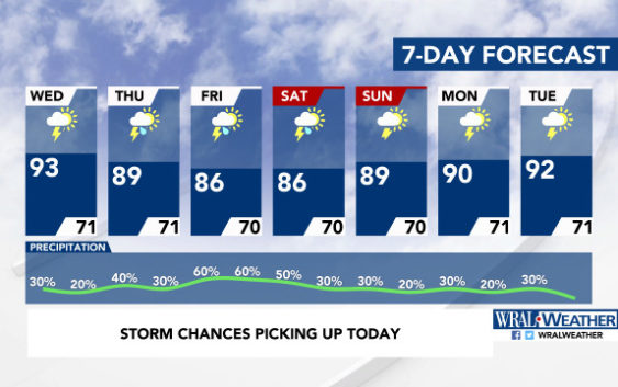
Raleigh, N.C. — The Triangle is under a Level 1, or marginal risk, for severe weather because of instability in the atmosphere that could bring heavy downpours and gusty winds to the region.
WRAL News meteorologist Mike Maze said the storms could form as the sun’s energy triggers isolated storms from the moisture in the air.
There’s a 30 percent chance of rain on Wednesday, with showers most likely occurring during the afternoon hours into the early evening.
Maze the storm chances will linger into Thursday, when there is a 40 percent chance for precipitation and more storms likely in the afternoon and evening.
By the end of the weekend, Raleigh could see 1.25 inches of rain.
The rain will bring cooler temperatures. While Wednesday’s high will be 93 degrees, Thursday’s high will be 89 degrees, and Friday’s will be 86 degrees.