- U.S.-based aid groups rush to get supplies into storm-battered Jamaica after Hurricane Melissa
- Travelers stuck in Jamaica due to Hurricane Mellissa forced to pay for unwanted extended stay
- Raleigh police officer awaits word from family in Jamaica after Hurricane Melissa devastation
- North Carolina’s leaders give insight on the effects of Hurricane Melissa
- ‘We want some answers;’ Whiteville residents demand city response to prevent flooding
Tracking Dorian: Most, least likely scenarios for hurricane's path
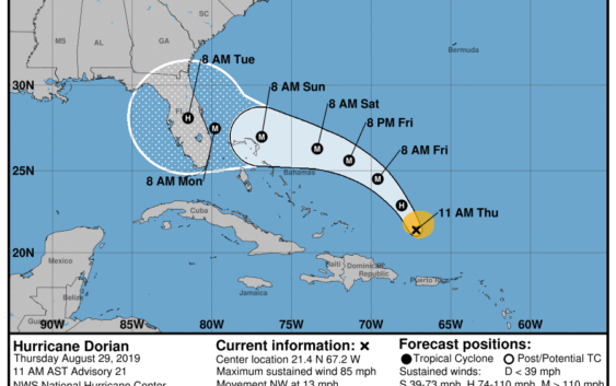
Hurricane Dorian continues to gain strength as it moves over the Atlantic Ocean, and it’s expected to make landfall on the U.S. mainland on Labor Day.
The Category 1 hurricane sustained wind speeds of 80 miles per hour as it passed Puerto Rico and the Virgin Islands, causing limited damage.
Yet forecasters are predicting several scenarios as the storm grows in size and intensity, with the “best case scenario” seeming like the least likely scenario.
MOST LIKELY SCENARIO:
The storm is moving toward the U.S. mainland, and will most likely make landfall along Florida’s east coast. Forecasters say the storm could be a Category 4 storm by the time it reaches the state.
Since 1900, eight Category 4 and 5 hurricanes have made landfall along the east coast of Florida. The most recent was 1992’s Hurricane Andrew, which had maximum wind speeds of 165 miles per hour.
This scenario includes tracks farther north toward Georgia or even south over the Florida Keys.
LEAST LIKELY SCENARIO:
Dorian will be pulled northward and remain in the Atlantic Ocean, without making landfall.
ANOTHER POSSIBILITY:
Dorian makes landfall in south Florida and then enters the Gulf of Mexico, with a potential second landfall in the Gulf Coast. This would affect Louisiana, Alabama, and/or Mississippi.
The variety of forecast scenarios is depicted in the National Hurricane Center’s “spaghetti plot,” which shows various computer models with variances that make the picture look like a plate of spaghetti.
Copyright © 2019 WTVD-TV. All Rights Reserved.