- Road closures reported due to flooding in Myrtle Beach
- Town of Wrightsville Beach preparing for coastal flooding this weekend
- Man charged with sparking the most destructive wildfire in Los Angeles history
- Carolina Hurricanes start 2025-26 season hosting New Jersey Devils
- Speedy Sparks, bassist for Texas Tornados, other San Antonio music icons, has died
Hurricane Dorian's outer bands lash Florida's east coast
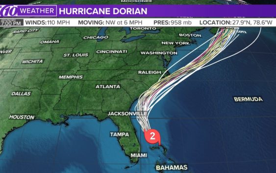
ST. PETERSBURG, Fla — Hurricane watches and warnings have been expanded along the U.S. southeast coast as Hurricane Dorian finally makes a move on away from the Bahamas.
Dangerous winds and life-threatening storm surge will continue through this evening and into the day Wednesday as the outer bands of the storm roll in across Florida’s east coast.
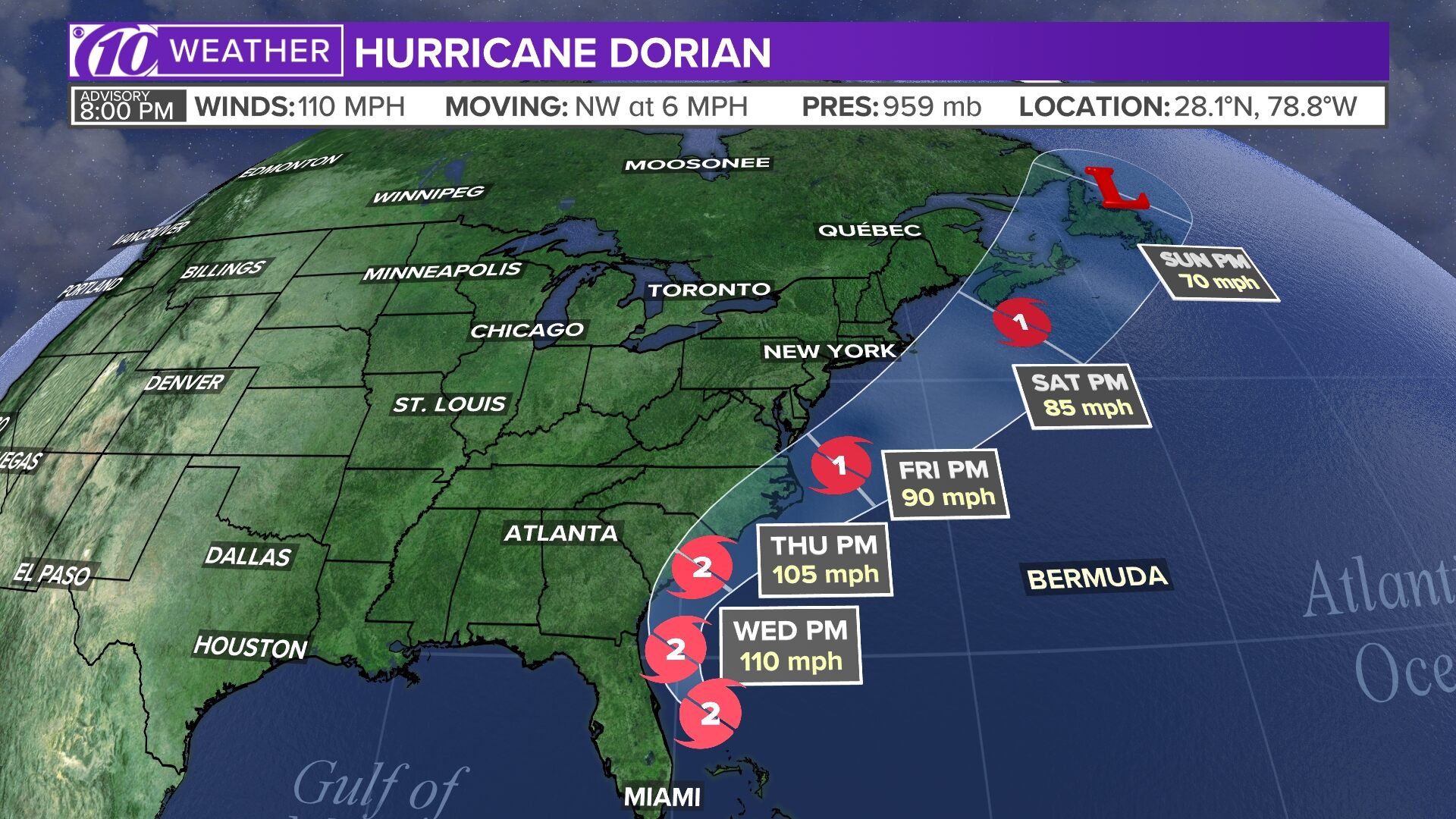
Dorian is a Category 2 storm with maximum sustained winds of 110 mph. As of the latest National Hurricane Center update, Dorian was located about 110 miles east of Cape Canaveral, Florida. It’s moving to the northwest at 6 mph.
People living in parts of the northern Bahamas have been dealing with hours of nonstop storm surge up to roofs and strong winds.
Dorian first made landfall in Elbow Cay, Bahamas, around 12:45 p.m. Sunday with maximum sustained winds of 185 mph as a Category 5 hurricane. Hurricane Dorian’s falling wind speeds since then made it a Category 4 storm Monday morning. From there, it weakened further.
However, Dorian remains an extremely destructive storm.
The most reliable weather computer models have been consistent in keeping the powerful storm just off the Florida coast and away from landfall. These models, however, are not forecasts — and they tend to change with every update.
In fact, some models include parts of Florida’s east coast for significant impacts.
LIVE BLOG: The latest, need-to-know information on Hurricane Dorian
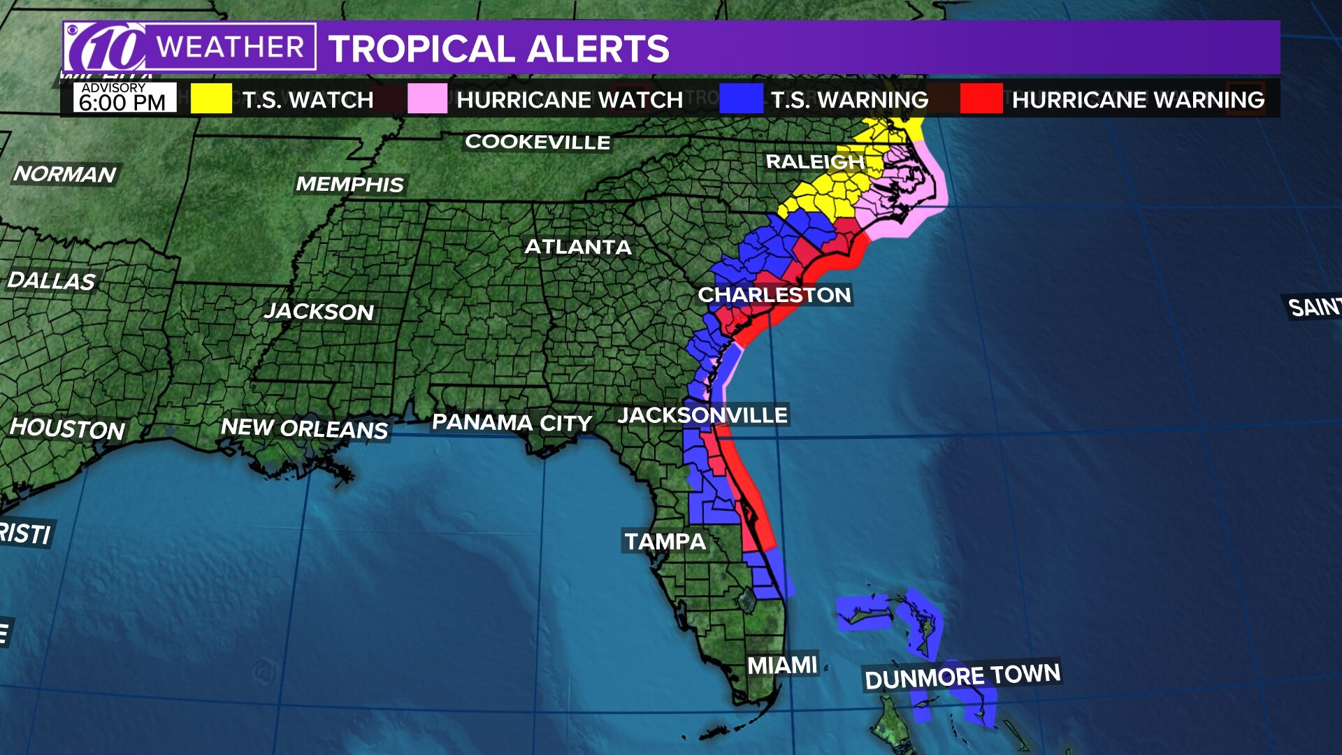
The following watches and warnings are in effect:
- Hurricane warning: Sebastian Inlet to Ponte Vedra Beach, Florida; north of Savannah River to Surf City, North Carolina
- Hurricane watch: North of Ponte Vedra Beach, Florida, to Savannah River; north of Surf City, North Carolina, to the North Carolina/Virginia border; Albemarle and Pamlico Sounds
- Tropical storm warning: Grand Bahama and the Abacos Islands in the northwestern Bahamas; north of Ponte Vedra Beach, Florida, to Savannah River; Jupiter Inlet to Sebastian Inlet, Florida
- Tropical storm watch: The North Carolina/Virginia border to Chincoteague, Virginia; Chesapeake Bay from Smith Point southward
- Storm surge warning: Jupiter Inlet, Florida, to Surf City, North Carolina
- Storm surge watch: North of Surf City to Duck, North Carolina; Pamlico and Albemarle Sounds and Neuse and Pamlico Rivers
RELATED: What’s the difference between a hurricane watch and a warning?
The National Hurricane Center said hazards for the islands include powerful wind gusts and storm surge 12-18 feet above normal tide levels, with possibly higher waves.
Dorian’s turn northwest is a positive forecast for the Tampa Bay region but one of most concern for Florida’s east coast because a slow, powerful storm that rides the coastline is likely to bring more prolonged and significant impacts. Florida is technically out of the cone of uncertainty in the latest hurricane track, but that definitely doesn’t mean the coast is out of the woods.
Again, stay tuned to the latest forecast as Dorian’s track and intensity become more certain.
►Track the weather and get severe alerts when they happen: Download the 10 News app now.
►Stay informed with all tropical weather: Check out our must-have interactive Hurricane Headquarters guide here.
Spaghetti models
Each line represents a computer model’s best “guess” of where the center of the storm will go. Together, they look like spaghetti noodles. Remember, impacts from a tropical system can and do occur miles away from the center.
App users — tap here if you cannot see the image below.
Tropical track
This is the latest “cone of uncertainty,” which shows an area where the center of the storm could go, when and how strong it might be at the given time.
App users — tap here if you cannot see the image below.
Watches and warnings
What’s a watch? What’s a warning? Here are the official alerts that can be issued for your area and what you should do.
App users — tap here if you cannot see the image below.