- Families of campers, counselors who died in Texas Hill County floods sue Camp Mystic
- Small plane bound for Jamaica with hurricane relief supplies crashes in Florida neighborhood
- Ask the Meteorologist: Did a tornado hit Johnston County Saturday night?
- Demolition begins on flood-damaged homes in Stoney Creek as neighbors await relief
- NC Office of State Fire Marshal aiding in Hurricane Melissa relief efforts
Subtropical Storm Melissa forms off US coast
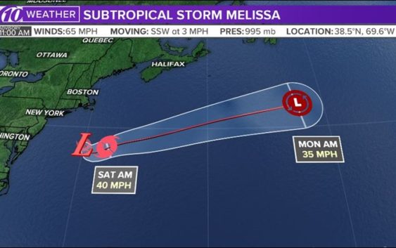
Subtropical Storm Melissa has formed southeast of New England.
The National Hurricane Center says Melissa is currently about 190 miles south of Nantucket, Mass. It’s packing 65 mph winds and chugging along south-southwest at 3 mph.
Melissa is expected to turn toward the east-northeast while increasing in forward speed Friday night and into the weekend. Forecasters expect the system to move away from the east coast of the United States and gradually weaken over the next couple of days. Melissa could lose its subtropical characteristics as early as Saturday night.
Right now, winds of 40 mph are extending as far out as 345 miles from the center. Coastal flooding is possible Friday for parts of the east coast from the mid-Atlantic states to southeastern New England. Meteorologists are also asking people to be aware of potentially dangerous surf and rip current conditions that may result from Melissa.
There are currently no coastal tropical cyclone watches or warnings in effect.
There is no threat to Florida.

10News
RELATED: How to prepare for a hurricane before it arrives
RELATED: What’s the difference between a hurricane watch and a warning?
What other people are reading right now:
FREE 10NEWS APP:


►Stay In the Know! Sign up now for the Brightside Blend Newsletter