- Families of campers, counselors who died in Texas Hill County floods sue Camp Mystic
- Small plane bound for Jamaica with hurricane relief supplies crashes in Florida neighborhood
- Ask the Meteorologist: Did a tornado hit Johnston County Saturday night?
- Demolition begins on flood-damaged homes in Stoney Creek as neighbors await relief
- NC Office of State Fire Marshal aiding in Hurricane Melissa relief efforts
Tropical Storm Nestor forms in Gulf of Mexico, path could cross North Carolina
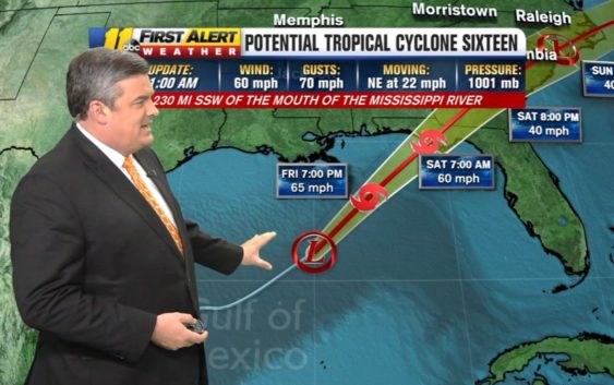
RALEIGH (WTVD) — A tropical storm could bring rain to North Carolina this weekend.
Tropical Storm Nestor is gaining strength in the Gulf of Mexico. Nestor officially became a tropical storm Friday afternoon. The storm had maximum sustained winds of 60 miles per hour and was moving northeast at 22 mph as of the 2 p.m. advisory.
The disturbance over the Gulf of Mexico is now Tropical Storm #Nestor. Storm surge and tropical storm warnings continue for portions of the northern Gulf Coast. Dangerous storm surge and tropical storm force winds are expected later today and tonight. https://t.co/tW4KeFW0gB pic.twitter.com/3CxbQqnL0v
— National Hurricane Center (@NHC_Atlantic) October 18, 2019
It is currently expected to develop into Tropical Storm Nestor and move northeast into the Florida panhandle and eventually up through Georgia, South Carolina and North Carolina.
It is expected to make landfall sometime during the day Saturday.
After hitting land, it will weaken and turn into an area of low pressure. That system will move across North Carolina on Sunday.
It will mostly be a rain event, but wind gusts could get up to 45 miles per hour in some areas.
Copyright © 2019 WTVD-TV. All Rights Reserved.