- Families of campers, counselors who died in Texas Hill County floods sue Camp Mystic
- Small plane bound for Jamaica with hurricane relief supplies crashes in Florida neighborhood
- Ask the Meteorologist: Did a tornado hit Johnston County Saturday night?
- Demolition begins on flood-damaged homes in Stoney Creek as neighbors await relief
- NC Office of State Fire Marshal aiding in Hurricane Melissa relief efforts
Severe weather threatens Raleigh and the Sandhills on Thursday; flooding, strong winds likely
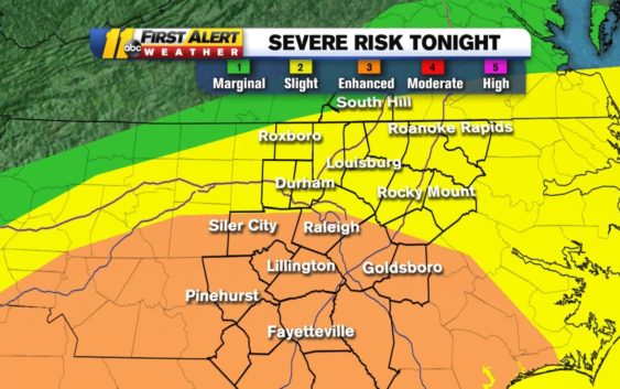
RALEIGH (WTVD) — Part of the Triangle is under a Category 3 risk for severe weather Thursday.
The National Weather Service expanded its ‘enhanced’ area into the southern portion of the ABC11 viewing area. Raleigh. Johnston, Harnett, Lee, Moore and Cumberland counties are now all under an enhanced risk for severe weather Thursday.
SEVERE WEATHER TIMELINE
Light and moderate rain moved into central North Carolina in the early morning hours. Rain will remain throughout the morning commute before a brief hiatus.
By 11 a.m., another round of showers will pull through and storms will intensify in the afternoon.
In addition to the wind threat, areas west of Interstate 95 are under a Flood Watch through late Thursday night.
Heavy rain and damaging winds are the primary threats with Thursday’s storms. There is also an isolated chance for popup tornadoes.
The storms will last through the afternoon and evening. They will move out of central North Carolina overnight.
Here are the latest risks from Bigweather.
After the storms temperatures will briefly cool down — with a chance for below freezing temperatures overnight Friday into Saturday morning. We will warm up by Monday and another chance of showers arrives Tuesday.
Copyright © 2020 WTVD-TV. All Rights Reserved.