- Travis County is raising property taxes to pay for past and future floods
- Many ask where the hurricanes are this season as the Atlantic remains quiet
- Texas passed laws to address historic flooding. We asked a flood expert if they'll work.
- A city in Brunswick County is still repairing after Hurricane Florence
- Stein calls For $13.5 billion In new funding from Congress for Hurricane Helene Recovery
Flash Flood Warning | Jefferson, Orange, Hardin Co. under flood threat until 5:15 p.m.
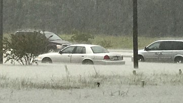
ORANGE COUNTY, Texas — A FLASH FLOOD WARNING has been issued for Jefferson, Hardin and Orange Co. until 5:15 p.m. This includes Beaumont and Orange.
12News StormTracker Chief Meteorologist Patrick Vaughn is tracking a stalled storm cell that is dumping rainfall at rates of 4″ per hour. Radar estimates show more than 9″ of rain has fallen along I-10 south of Maurcieville.
A band of showers and thunderstorms are currently setup along the I-10 corridor and a boundary has formed from Hardin to Orange Co. The storms are not moving, but are expected to slowly diminish over the next few hours.
“A moist, south flow off the Gulf of Mexico is producing locally heavy rainfall along this boundary,” Vaughn says. “High res modeling shows this moving north in the next two hours, however, uncertainty is high.”
Digital storm total accumulation shows some areas of Orange Co. have seen nearly 7-inches of rainfall. An area between Mauriceville and Bridge City along Hwy. 62 have had 6.60″ of rainfall in a short amount of time.
Pictures from residents living in Orange show minor street flooding.
In Beaumont, police have blocked off the feeder road along Eastex Fwy. near Lucas Dr. Southbound traffic is moving very slowly, 12News reporter Tyler Seggerman reports.
IF YOU SEE FLOODING IN YOUR AREA: Send us your photos and/or video by texting 409-838-1212.
Flash flooding across Southeast Texas
