- U.S.-based aid groups rush to get supplies into storm-battered Jamaica after Hurricane Melissa
- Travelers stuck in Jamaica due to Hurricane Mellissa forced to pay for unwanted extended stay
- Raleigh police officer awaits word from family in Jamaica after Hurricane Melissa devastation
- North Carolina’s leaders give insight on the effects of Hurricane Melissa
- ‘We want some answers;’ Whiteville residents demand city response to prevent flooding
Arthur: First tropical storm of the season forms off eastern coast of Florida, watch in place for NC coast
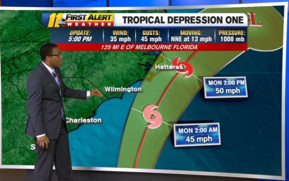
The first tropical storm of the season, Arthur, has formed off the eastern coast of Florida Saturday night.
The National Hurricane Center issued a tropical storm watch for a portion of the North Carolina coast after a Tropical depression formed off the coast of east-central Florida on Saturday afternoon.
The watch is issued for the North Carolina coast starting from Surf City to Duck and including the Pamlico and Albemarle Sounds.
A watch is used when the risk of a hazardous weather or hydrologic event has increased significantly, but its occurrence, location, and/or timing is still uncertain. It is intended to provide enough lead time so that those who need to set their plans in motion can do so.
The tropical storm is moving north-northeast at 13mph with sustained winds of 13 mph and gusting up to 45 mph. While the system will have minimal impact for central North Carolina, the storm will impact coastal regions on Monday. Heavy rains will be expected for the coast.
Tropical storm force winds and rains will arrive on the North Carolina coast on Monday. Main threats will be gusty winds, heavy rain and dangerous coastal surf. More tonight on @ABC11_WTVD #ncwx pic.twitter.com/XF6PHrkxi7
— Robert Johnson (@RobJohnsonABC11) May 16, 2020
This will be the sixth year in a row we’ve had a Tropical or Sub-Tropical system develop before Hurricane season begins, which is June 1.
According to the center, the depression will make for dangerous coastal surf conditions and rip currents as the system moves northward from Florida and into the mid-Atlantic for the next few days.
Copyright © 2020 WTVD-TV. All Rights Reserved.