- U.S.-based aid groups rush to get supplies into storm-battered Jamaica after Hurricane Melissa
- Travelers stuck in Jamaica due to Hurricane Mellissa forced to pay for unwanted extended stay
- Raleigh police officer awaits word from family in Jamaica after Hurricane Melissa devastation
- North Carolina’s leaders give insight on the effects of Hurricane Melissa
- ‘We want some answers;’ Whiteville residents demand city response to prevent flooding
Level 1 risk for severe weather in effect as chance for storms continue into Friday
Parts of the Triangle westward will continue to be under a level 1 risk for severe weather for the rest of the day Thursday.
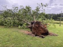
The entire state has a chance of thunderstorms. Durham, Orange, Chatham, Moore, Lee, Person and Granville counties could see the most damaging rain and wind gusts. The storms Thursday and Friday won’t be as powerful as what residents saw Wednesday, when there were two tornado warnings, including an EF-0 tornado that touched down in Warren County.
Halifax County has a flood warning in place until further notice. On Friday, the Lower Roanoke River near Scotland neck is expected to rise above flood stage at midnight and rise near 30 feet by Sunday morning. If the river reaches 31 feet high, then there is widespread flooding on the bank, according to the National Weather Service.

First thing Friday morning there will be waves of rain rolling through. The threat for rain and storms decreases in the Triangle, though Person, Granville and Vance counties will be under a level 1 risk.
Both Friday and Saturday will be hot and humid, with highs in the low 80s and scattered showers.

Sunday will be dry, less humid and pleasant, with a high in the upper 70s.