- U.S.-based aid groups rush to get supplies into storm-battered Jamaica after Hurricane Melissa
- Travelers stuck in Jamaica due to Hurricane Mellissa forced to pay for unwanted extended stay
- Raleigh police officer awaits word from family in Jamaica after Hurricane Melissa devastation
- North Carolina’s leaders give insight on the effects of Hurricane Melissa
- ‘We want some answers;’ Whiteville residents demand city response to prevent flooding
90-degree heat, severe weather potential ahead

Wednesday will be the first 90-degree day since October, according to WRAL meteorologist Elizabeth Gardner.
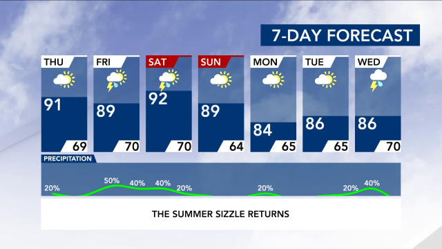
It will be the hottest day of the year so far, and of the entire week, with a high around 93 degrees in Raleigh and 94 degrees in Fayetteville.
The hot day came later this year — most of the time we see our 90-degree day earlier, like in May.
Right now we are seeing tropical air, Gardner said. It’s hot, humid and sticky. From June through August, we are in meteorological summer — which means hot weather is here to stay.
The day will be sunny and clear before a chance for storms moves in Thursday. Much of central North Carolina will be under a level 1 risk for severe weather, with showers and storms possible.
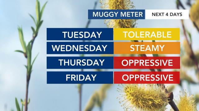
Highs will be in the upper 80s to low 90s, but the humidity will be oppressive.
The weekend will stay hot, with temperatures in the low 90s. Friday and Saturday could also be hot and stormy, but Sunday should be more pleasant when dew points fall back into the upper 40s to lower 50s, making for a much less humid afternoon.
Hurricane season officially started Monday, though North Carolina already was impacted by two named storms — Arthur and Bertha. On Wednesday, Tropical Storm Cristobal made landfall on the southern Gulf of Mexico, bringing some flooding to Mexico’s southern Gulf coast and threatening more deadly inundations farther inland.

