- U.S.-based aid groups rush to get supplies into storm-battered Jamaica after Hurricane Melissa
- Travelers stuck in Jamaica due to Hurricane Mellissa forced to pay for unwanted extended stay
- Raleigh police officer awaits word from family in Jamaica after Hurricane Melissa devastation
- North Carolina’s leaders give insight on the effects of Hurricane Melissa
- ‘We want some answers;’ Whiteville residents demand city response to prevent flooding
Flash Flood Warning issued for 3 counties including the Katy area | View live radar
Some downpours will create brief heavy rain and minor street flooding this morning.
HOUSTON — A Flash Flood Warning was just issued for northwestern Fort Bend County, Harris County and southeastern Waller County until 7 a.m. Thursday.
This includes the Rosenberg, Richmond, Pecan Grove, Katy, Jersey Village, Mission Bend, and Spring Branch areas shaded in red here:
Watch Meteorologist Chita Craft on #HTownRush – live on KHOU 11 now
A Flash Flood Watch is also in effect for a portion of Southeast Texas, including the following areas: Austin, Colorado, Fort Bend, Harris, Waller and Wharton until 10 a.m. Thursday.
* A slow-moving line of showers and thunderstorms extending from Harris County into Colorado and Wharton Counties has remained in place for the last several hours, resulting in high amounts of rainfall rates. Hourly rainfall rates of upwards of 2 inches per hour have been observed with these storms. Isolated rainfall totals of 2 to 4 inches or higher will be possible through the mid morning hours, which may lead to flash flooding.
TRACK THE WEATHER: Houston weather radar
GET ALERTS ON YOUR PHONE: Download the KHOU 11 app
TRAFFIC UPDATES: View Houston incidents
* Areas in the watch include the cities of Houston, Columbus, Prairie View, Brookshire, Sealy, Hempstead, Pecan Grove, First Colony, Eagle Lake, Wharton, El Campo, Mission Bend, Missouri City, Rosenberg, Waller, Bellville, Sugar Land, and Weimar.
Areas along closer to the coast, including southern portions of Harris County, are not included in the watch at this time.
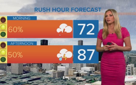
Right now it looks like we will receive two rounds of rain Thursday. One in the very early morning and then another in the warmth of the afternoon. The major concern will be ponding and water in the roadway, not flooding of structures. Stay weather aware and check the radar if you must get on the roads.
LIVE: View Houston TranStar cameras

HOUSTON 7-DAY FORECAST
Rain chances will diminish but not completely go away this weekend as dust from the Saharan Desert arrives. As the dust moves in, skies may become a bit hazy.
The good news with the dust, which is over the Atlantic Ocean and moving into the Caribbean Sea soon, has helped keep the tropics calm, so no hurricanes and tropical storms anywhere in sight, likely for the rest of this month. Tropical Storm Dolly, is the exception, since it formed in the Northern Atlantic Ocean but will pose no threat to land.