- U.S.-based aid groups rush to get supplies into storm-battered Jamaica after Hurricane Melissa
- Travelers stuck in Jamaica due to Hurricane Mellissa forced to pay for unwanted extended stay
- Raleigh police officer awaits word from family in Jamaica after Hurricane Melissa devastation
- North Carolina’s leaders give insight on the effects of Hurricane Melissa
- ‘We want some answers;’ Whiteville residents demand city response to prevent flooding
Scattered thunderstorms and showers expected all day, damaging winds possible
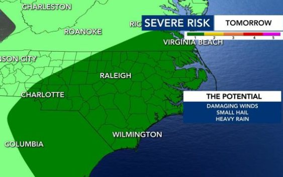
Scattered thunderstorms and showers are moving across the Triangle Thursday afternoon, said WRAL meteorologist Elizabeth Gardner.
A Level 1 risk for severe storms is in place this afternoon. Areas in central North Carolina will likely see pop-up thunderstorms with heavy rain throughout the night.
At around noon, Hillsborough and Henderson saw heavy rain. Henderson even had reported lightning.
Many communities will be affected by the storms rolling in, so it’s important to stay on guard.
“It doesn’t matter where you are, you could see a severe storm,” Gardner said. “It’s more likely from the Triangle area westward.”
From 4 p.m. to 8 p.m., expect to see 50 to 60 mile per hour wind gusts if you are under a severe weather warning.
Tornados are unlikely Thursday — but hail isn’t. Starting from 4 p.m., expect to see quarter-size hail if you are in the path of the band of scattered thunderstorms.
Flash flooding is unlikely. Places that get drenched with heavy rain will still only see half an inch of rain, Gardner said.
Gardner said there will not be many strong storms; rather, there will be small “pop-up” storms and rain throughout the afternoon.
Temperatures will top off in the mid 80s across central North Carolina.
Friday and the weekend will be dry with more sunshine and temperatures in the lower 90s. Saturday will be the hottest day, with a high around 93 degrees. Next week, there is a chance of rain at 40%. Despite the chance of severe storms, this week is expected to be drier than next week.
