- Wildfire raging in rural area west of Fredericksburg
- Tornado trio: Three tornadoes strike same county 11 hours, 14 miles apart
- City of Southport urging long-time and new residents to prepare for hurricane season
- Crews battle wildfire in rural area west of Fredericksburg
- 'It was just that fast': Edgecombe County wakes to tornado warnings, homes, cars damaged
Isaías continuing as Tropical Storm up the coast
Isaías has weakened a little further now with sustained winds at 65 mph and wind gusts to borderline hurricane strength of 75 mph. The unorganized storm has been fighting dry air and wind shear currently but warm water should allow it to maintain its current strength with a deviation of 5 mph or so. This overall track has shifted slightly closer to the US coast and will continue to follow the shoreline up into South Carolina where Isaias will make landfall around
Isaias has been struggling to remain organized as wind shear has been breaking up the storm and weakened it momentarily, but it is forecast to restrengthen into a hurricane tonight before continuing to weaken as it moves along the southeast coast.
Regardless, Isaias will be weaker by the time it gets to the Carolinas and will be picking up speed. Forward wind speed will likely double keeping Tropical Storm conditions less than 6 hours for any given area in the eastern Carolina’s.
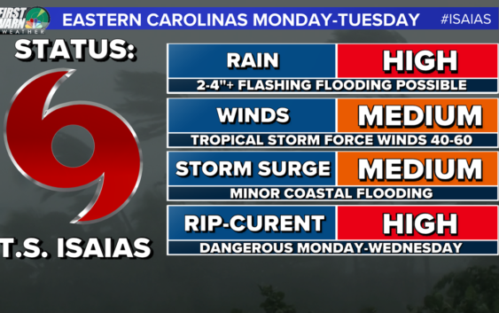
Our best news here is the speed at which this storm will move through the Carolinas. This limits all of the above expect for dangerous rip currents which are active even for this weekend.
RELATED: ‘Now is the time to prepare,’ Gov. Cooper declares a state of emergency ahead of Hurricane Isaias
YOUR LOCAL IMPACTS:
For the Charlotte area back to Hickory and Boone we might not even know it’s out there. We will see some clouds and breezy conditions, at times. The bigger impacts for rain will come from a slow-moving upper low and trough that will be hanging over the region through most of next week. Still, heavy rain and storms are possible through your late Monday and Tuesday morning associated with the outer bands working with that low mentioned above to promote scattered to widespread rain.
Stay tuned for later updates and follow up on Social Media for more updates on the storm as it gets closer to the Carolinas. Track forecast updates are coming out every day at 5AM, 11AM, 5PM, and 11PM until the storm is gone.