- Families of campers, counselors who died in Texas Hill County floods sue Camp Mystic
- Small plane bound for Jamaica with hurricane relief supplies crashes in Florida neighborhood
- Ask the Meteorologist: Did a tornado hit Johnston County Saturday night?
- Demolition begins on flood-damaged homes in Stoney Creek as neighbors await relief
- NC Office of State Fire Marshal aiding in Hurricane Melissa relief efforts
FORECAST: Flash Flooding this evening
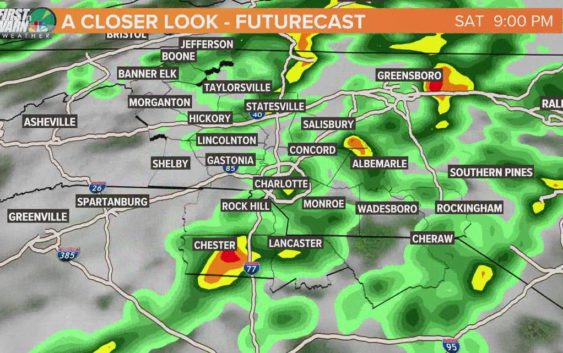
CHARLOTTE, N.C. — Most of the area is under a moderate threat for Flash Flooding this evening.
Flash flooding will be the biggest concern on what will be an overall active weather day. Most of the day appears to be overcast with a break or two in clouds being possible.
It is this area in the Foothills that has seen the most rain from the overnight. Rain will be slow-moving at times, with heavy rain rates over 2″+ per hour.
This rain will continue through the evening, so stay weather aware through this time frame. Rain will end tonight and we will have our basic chance for isolated storms again tomorrow but the day looks to be much drier. Rain chances will be in the isolated category Sunday through Tuesday but will become more likely again to end the workweek.
TEMPERATURES:
Today will be cooler in the lower to mid 80’s due to additional cloud cover but it will still feel like the upper 80’s. Most of this week looks to be ranging in the 80’s creating a nice opportunity to get a break from the 90’s this time in August.
Sunday through Tuesday will likely be closer to the upper 80’s and will feel like the 90’s. But with more clouds and chances for scattered to widespread rain to end the week… we will fall back to the mid 80’s into next weekend.
TROPICAL UPDATE:
Tropical Storm Josephine is WNW at 15 mph and is still not treat to making landfall. It is turning towards the Carolinas but will continue to turn away from the US here in the coming days. Josephine’s name will be put back on the shelf here soon once it drops below Tropical Storm strength late Sunday.
The low that was off of the Carolina Coast is now our 11th named storm of the season. This was the earliest K name on record beating out Katrina only for early timing. Kyle is maxed out as a weak Tropical Storm and will be reduced to a depression by the end of this weekend.