- Texas passed laws to address historic flooding. We asked a flood expert if they'll work.
- A city in Brunswick County is still repairing after Hurricane Florence
- Stein calls For $13.5 billion In new funding from Congress for Hurricane Helene Recovery
- Governor Stein expected to ask for federal release of Hurricane Helene relief funds in NC on Monday
- UNCW students honor Hurricane Florence anniversary at diaper bank
Tropical Storm Laura and Marco both expected to become hurricanes
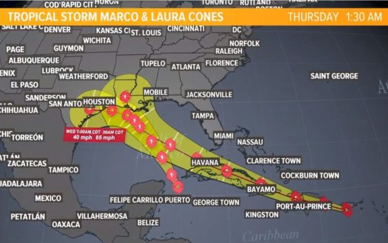
Both storms should be in the Gulf of Mexico at the same time next week.
HOUSTON — All eyes are on the Gulf of Mexico as Tropical Storm Laura and Tropical Storm Marco move near the Gulf of Mexico. Marco is expected to become a hurricane tonight. Laura should gain hurricane strength early next week.
We’re tracking the latest on those two storms here.
As for our local forecast, we’re looking at typical August weather. It’s going to be hot and muggy with an isolated chance of afternoon storms on Saturday, with a smaller chance Sunday.
A round of storms is pushing from the west to the north, coming just west of Houston. The sea breeze will help fire off storms Saturday afternoon.