- Travis County is raising property taxes to pay for past and future floods
- Many ask where the hurricanes are this season as the Atlantic remains quiet
- Texas passed laws to address historic flooding. We asked a flood expert if they'll work.
- A city in Brunswick County is still repairing after Hurricane Florence
- Stein calls For $13.5 billion In new funding from Congress for Hurricane Helene Recovery
Tropical Storm Laura's track shifts closer to Houston and Texas
-
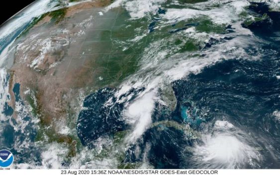
A satellite image shows both tropical storms, Marco and Laura, on the morning of Sunday, Aug. 23.
A satellite image shows both tropical storms, Marco and Laura, on the morning of Sunday, Aug. 23.
Photo: National Hurricane Center
A satellite image shows both tropical storms, Marco and Laura, on the morning of Sunday, Aug. 23.
A satellite image shows both tropical storms, Marco and Laura, on the morning of Sunday, Aug. 23.
Photo: National Hurricane Center
The latest forecast cone for Tropical Storm Laura has taken a turn to the west, again raising concerns that the storm could make landfall in Southeast Texas this week.
Laura is near Cuba on Sunday morning.
PREP TIPS: Houstonians on what they wish they’d done before the last hurricane
“While the details of the long-range track and intensity forecasts remain uncertain, Laura is forecast to strengthen over the Gulf of Mexico and there is an increasing risk of storm surge, rainfall, and wind impacts along portions of the U.S. Gulf Coast by the middle of the week,” the National Hurricane Center reports.
Tropical Storm Marco is expected to make landfall Monday on the Louisiana coast near Louisiana, although the National Hurricane Center reports the track could still shift between now and Monday.